ارزیابی راهکارهای مختلف برای مدیریت مشکلات منابع آب در کشاورزی آبیاری
چکیده
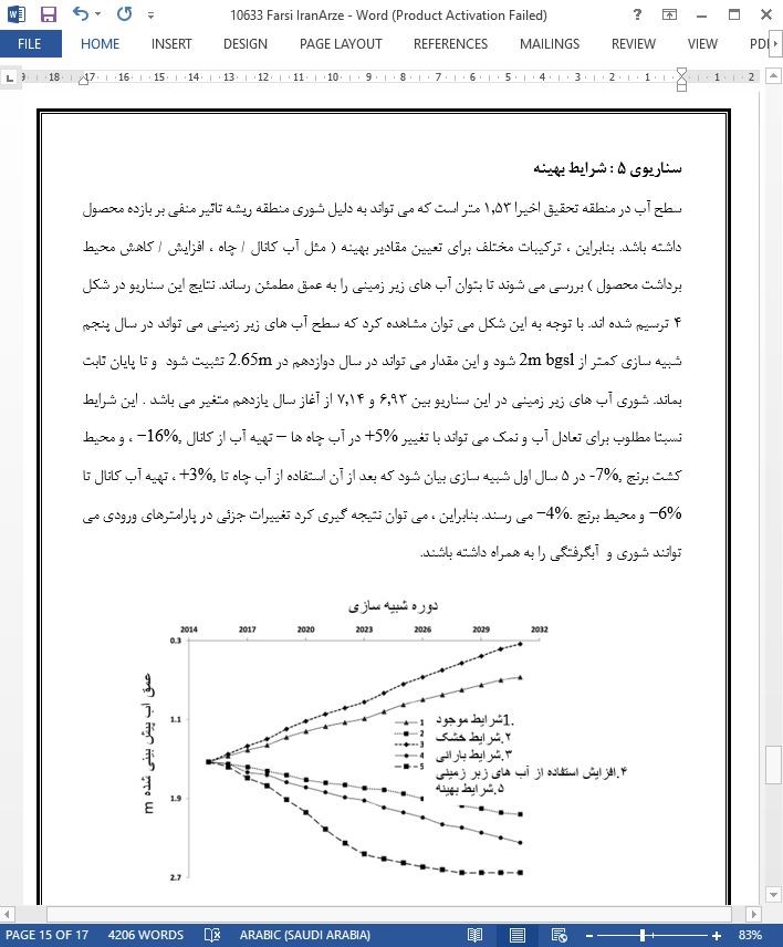
افزایش کشاورزی آبیاری برای دست یابی به امنیت جنگل لازم است. به هر حال ، این عامل می تواند منجر به افزایش مشکلات مرتبط با منابع آب از جمله کمبود و شوری آب شود. برای ارزیابی راهکارهای مختلف مدیریت در حل این مشکلات ، تحقیق حاضر از مدل شبیه سازی SaltMod در منطقه شمال غرب هند استفاده کرده است که این منطقه با مشکل شوری و آبگرفتگی مواجه است . بعد از انجام آزمایشات و محاسبه و اعتبار سنجی ، از این مدل برای بررسی گزینه های مختلف مدیریت آب در منطقه بیان شده استفاده شد. تحلیل سناریوهای مختلف نشان می دهد که سطح آب های زیر زمینی در منطقه در شرایط طبیعی بالا می رود. بنابراین ، گزینه های درست مدیریتی – برای مثال ، افزایش کاربری آب های زمینی – کاهش مناطق کشت برنج و کاهش استفاده از آب های کانال پیشنهاد می شوند. سناریوی ایده آل نشان می دهد که تغییرجزئی 6-3% در مقدار ورودی می تواند مشکل مسئله را شامل شود.
1. مقدمه
منابع آب و خاک محدود هستند و با کاهش تدریجی رو برو هستند ( چیت ساز و آذری وند 2007- سینگ 2018و2016). به علاوه ، تولیدات کشاورزی نیز با توجه به افزایش جمعیت و با استفاده از این منایع باید افزایش یابند( زی و همکاران 2018- لومبا و همکاران 2017- لی و ژانگ 2015 – سینگ 2018و2014 – لیو و همکاران 2016 – داویجان و همکاران 2016 ). افزایش کشاورزی آبی برای تشخیص امنیت غذا ( داس و همکاران 2015 – سینگ و همکاران 2016) در منطقه خشک داده شده با مقدار بارش نامناسب لازم می باشد ( هرمن و همکاران 2016 – آدهیکاری و همکاران 2017 – پوستل 1999). یه هر حال ، این افزایش می تواند منجر به ایجاد مشکلات منابع آب یا افزایش سطح آب زمینی و شوری ثانویه شود ( تیلمن و همکاران 2002 – هوک و همکاران 2006 – سینگ 2012-2017 ) . عباس و همکارانش در سال 2013 بیان کردند که شوری خاک در سطح جهانی در حال افزایش است و میانگین سالانه بیش از 2 میلیون هکتار است. در سال های اخیر ، سازمان غذا و کشاورزی FAO گزارش کرد که بیش از 19 درصد از تمام مناطق آبیاری شده از شوری رنج می برند (FAO 2016).
5 نتیجه گیری
با توجه به نتایج ارزیابی بدیهی است که SaltMod می تواند مدل مفیدی برای شبیه سازی عمق آب های زیر زمینی و شوری در مناطق کشاورزی باشد. این مدل می تواند تعادل آب خروجی و نمک را از طریق اقدامات مختلف را فراهم آورد. سطح آب در منطقه تحقیق می تواند در سال های پیش رو در شرایط کنونی افزایش داشته باشد. بنابراین ، اطمینان از برداشت محصول در منطقه تحقیق باتوجه به الگوهای موجود برداشت محصول ، خروج / ورود و شرایط آب شناسی/کشاورزی نمی تواند مستمر باشد. در شرایط بهینه ، کاهش در محیط کاشت برنج در برابر سایر محصولات غیر برنجی پیشنهاد می شود ، زیرا این کار می تواند کاهش قابل توجه در رشد منظم را سبب شود. علاوه بر کاهش محیط کشت برنج ، کاهش استفاده گسترده از آب های زیر زمینی و اب های کانال پیشنهاد می شود. کاهش آب های زیر زمینی می تواند با افزودن آب های چاه در مناطق جدید و تشویق کشاورزان / سهامداران به استفاده از آب های کم کیفیت و آب های کم کیفیت کانال برای اهداف آبیاری اتفاق بیفتد. سناریوی بهینه نشان می دهد که تغغیرات جزئی 3 تا 6 % در مقادیر ورودی می تواند مشکلات آب شناسی در منطقه تحقیق را سبب شود. گزینه های مدیریتی بحث شده در صورت اجرا می توانند کمک قابل توجهی به کاهش افزایش سطح آب های زیرزمینی و کاهش شوری در اراضی کشاوری کنند.
Abstract
The intensification of irrigated agriculture is required for attaining food security. It could result, however, in water resources problems of waterlogging and secondary salinization. To assess different management strategies in solving the problems, the current study used a simulation model SaltMod in a command area of north-west India which faced the problems of salinization and waterlogging. Following the thriving testing in the course of calibration and validation, it was used for studying various water management alternatives for the command area. The analysis of different scenarios shows that watertables in the command would persist to go up under the normal conditions. Thus, right management alternatives, for example, increased groundwater use, rice area reduction, and reduced canal water use are recommended. The ideal scenario revealed that small changes of 3–6% in input values would contain the problems of the study region.
1. Introduction
The water and soil resources are limited and they experience gradual degradation (Chitsaz and Azarnivand, 2017; Singh, 2018a, 2016a). Besides, farm production requires to be increased using these limited resources for feeding the burgeoning global population (Xie et al., 2018; Lomba et al., 2017; Li and Zhang, 2015; Singh, 2018b, 2014; Liu et al., 2016; Davijani et al., 2016). The intensification of irrigated agriculture is required for realizing food security (Das et al., 2015; Singh et al., 2016) in dry regions given that normal rainfall in these areas is highly unreliable (Herrmann et al., 2016; Adhikari et al., 2017; Postel, 1999). This intensification, however, could result in water resources problems of rising watertables and secondary salinization (Tilman et al., 2002; Houk et al., 2006; Singh, 2012, 2017a,b). Abbas et al. (2013) stated that soil salinization is growing globally at an average annual rate of over 2 million ha. In recent times, the Food and Agriculture Organization FAO reported that more than 19 percent of the total irrigated territory is suffered by salinization (FAO, 2016).
5. Conclusions
It is clear from evaluating the results that SaltMod appears to be a helpful model for the simulation of watertable depths and salinities in agricultural areas. It is capable of appraising the upcoming water and salt balances through a range of interventions. The watertables in the command area would persist to go up in the coming years in the existing conditions. Therefore, assured crop cultivation in the study region could not be continued under the present cropping pattern, discharge/recharge, and agro-hydro-meteorological settings. Under the optimal conditions, a decreased rice area against non-rice crops is recommended, since it could trim down percolation significantly. Apart from rice area reduction, enlarged use of groundwater and reduced canal water use are also recommended. Groundwater withdrawals can be augmented by putting in additional tubewells at fresh sites and encouraging stakeholders/farmers to utilize poor quality groundwater in conjunction with limited higher-quality canal water for irrigation purposes. The optimal scenario revealed that small changes of 3–6% in input values would contain the hydrological problems of the study region. The discussed management alternatives, if put into practice, will help significantly to lessen the groundwater table rise and secondary salinization of agricultural lands.

چکیده
1. مقدمه
2. سیستم تحقیق و اطلاعات
2.1 موقعیت و شرایط آبی
2.2 سیستم خاک و برداشت محصول
2.3 گرداوری اطلاعات
3. توصیف مدل
3.1 اصول
3.2 درجه بندی و اعتبار سنجی
3.3 تحلیل حساسیت
3.4 ارزیابی آماری
3.5 شبیه سازی راهکارهای مدیریت آب
4. نتایج و بحث
4.1 درجه بندی و اعتبار سنجی
4.2 تحلیل حساسیت
4.3 ارزیابی سناریوهای شبیه سازی شده
5. نتیجه گیری
ABSTRACT
1. Introduction
2. Study system and data
2.1. Location and hydrometeorology
2.2. Soil and cropping system
2.3. Data collection
3. Model description
3.1. Principle
3.2. Calibration and validation
3.3. Sensitivity analysis
3.4. Statistical evaluation
3.5. Simulation of water management strategies
4. Results and discussion
4.1. Calibration and validation
4.2. Sensitivity analysis
4.3. Assessment of simulated scenarios
5. Conclusions
- اصل مقاله انگلیسی با فرمت ورد (word) با قابلیت ویرایش
- ترجمه فارسی مقاله با فرمت ورد (word) با قابلیت ویرایش، بدون آرم سایت ای ترجمه
- ترجمه فارسی مقاله با فرمت pdf، بدون آرم سایت ای ترجمه
