دانلود مقاله افزایش خطر زمین لرزه در بارسلونا به دلیل اثرات تشدید ساختار خاک
چکیده
در این مطالعه، مطالعات قبلی در مورد ریزپهنه بندی در بارسلونا (اسپانیا) مجدداً مورد بررسی قرار گرفتند و دادههای موجود در مورد دورههای غالب خاکها در این شهر برای تهیه یک نقشه به روز شده از ریزپهنه بندی آن گردآوری شدند. علاوه بر این، پایگاه دادههای ساختمانی به روز رسانی شد و برای تهیه نقشهای از دورههای اصلی ساخت و ساز مورد استفاده قرار گرفت. عبور از دوره غالب خاک و تهیه نقشههای دوره اصلی منجر به کشف مناطقی شد که در آنها رویدادهای تشدید و در واقع افزایش تقویت پاسخ سازهای انتظار میرود. بنابراین، مناطقی از بارسلونا که در آن خطر زمین لرزه احتمالاً به دلیل وجود اثرات تشدید بیشتر است شناسایی شد. بهبود نقشههای ریزپهنه بندی و کشف مناطق تشدید ساختار خاک کمک قابل توجهی به افزایش دقت و آگاهی از خطرات زمین لرزه در بارسلونا میکند.
1. مقدمه
خطر زمین لرزه به عنوان احتمال یا میزان هزینه پیش بینی شده برای زمین لرزه در یک دوره زمانی مشخص، تعریف میشود. برای مطالعه خطرات زمین لرزه و افزایش آگاهی نسبت به آن در یک منطقه مشخص باید سه جنبه را در نظر گرفت: خطرات، بیرون زدگی/ آسیب پذیری و ارزش کالاهای نمایان. خطر زمین لرزه، احتمال یا میزان وقوع زمین لرزه را در سال مشخص میکند که با این موارد تعیین میشود:1) مطالعات منابع لرزهای، از جمله توزیع هندسی گسلها، مکانیسم کانونی و مدلهای رخداد مجدد زلزله، 2) محاسبه معادلات پیش بینی حرکت زمین (GMPE) و 3) توصیف ویژگیهای اثرات محلی از جمله اثرات خاک، توپوگرافی و اثرات القاء شده مانند زمین لغزش و روانگرایی خاک (1). نتایج بررسی یک خطر به ما امکان میدهد که احتمالات فراتر از آستانه مشخص شده از حرکات زمین را در طی یک دوره زمانی خاص تعیین کنیم. آستانه حرکت زمین، ممکن است از نظر شدت ریزپهنه بندی، بیشینه شتاب زمین یا مقادیر طیفی از پاسخ سازهای، در بین بسیاری از پارامترهای دیگر سنجیده شود.
5. بحث و نتیجه گیری
اگرچه بارسلونا شهری است که در منطقهای با خطر کم تا متوسط زمین لرزه واقع شده است، اما میزان خطر و آسیب پذیری بالایی دارد بنابراین خطر زمین لرزه در آن قابل توجه است و انجام مطالعات برای کاهش آن بسیار توصیه میشود. از آنجاییکه وقوع زمین لرزه را نمیتوان پیش بینی کرد، تنها راه برای کاهش اثرات ناشی از این رویدادها این است که از نظر ایمنی سازهای در طراحی و ساخت ساختمانها و زیرساختهای مقاوم در برابر زلزله و برنامه ریزی و مدیریت وضعیت اضطراری بلافاصله پس از وقوع زلزله، به شدت از تأثیر وقوع آن پیشگیری شود.
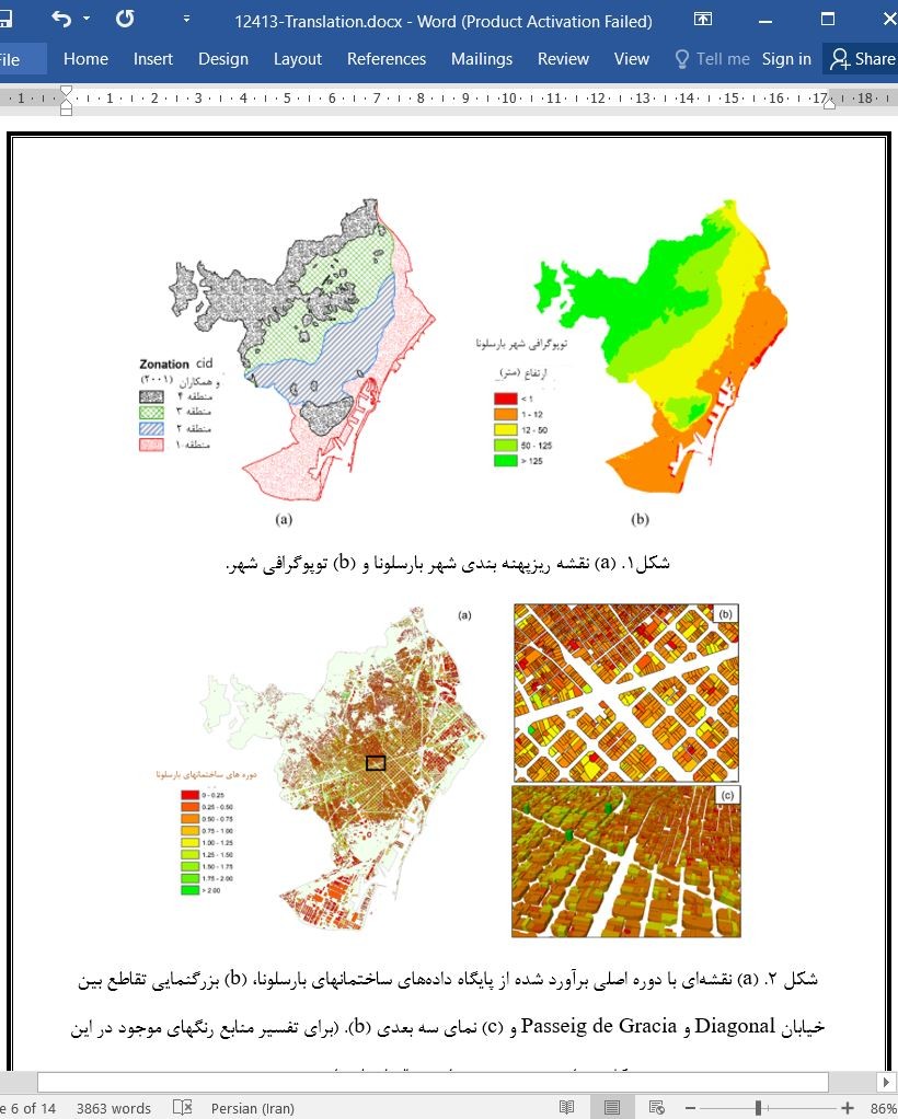
در این مطالعه، نقشههایی از دورههای خاک و ساختمانی بارسلونا تهیه شدند. با همبستگی متقابل و تحلیل هر دو نقشه، نقشه جدیدی ایجاد شد که بر مناطقی که پدیدههای تشدید ساختار خاک در آن مورد انتظار است تاکید دارد. این مطالعه در زمانیکه اثرات محلی در بررسیهای خطر منطقهای و محلی زمین لرزه در نظر گرفته میشود، نقش مهمی در آگاه سازی نسبت به خطر زمین لرزه در شهر دارد. نقشههایی که در اینجا تهیه شد میتوانند به کاهش خطر زمین لرزه کمک کنند، زیرا میتوانند توجه خاصی را به سازههای آسیب پذیر در برابر اثرات تشدید جلب کنند. علاوه براین، یک نقشه ریزپهنه بندی مبتنی بر دورههای غالب خاک را میتوان برای توسعه طیفی از طرحهای بهبود یافته بر اساس دوره مختص آن محل، در آیین نامه ساختمانی اجرا کرد.
Abstract
In this study, previous microzonation studies in Barcelona (Spain) were revisited, and available data on the predominant periods of soils in the city were compiled to develop an updated microzonation map of the city. In addition, the building database was updated and used to create a map of building fundamental periods. The crossing of soil predominant period and building fundamental period maps led to the detection of areas in which resonance phenomena and, indeed, increased amplification of the structural response are expected. Thus, zones of Barcelona were identified in which the seismic hazard is probably greater due to resonance effects. The improved microzonation maps and the detection of soil-building resonance areas contribute significantly to enhanced precision and awareness of seismic hazard and risk in Barcelona.
1. Introduction
Seismic risk is defined as the probability or rate of the expected cost due to earthquakes in a specific period of time. Three aspects must be considered to study and develop knowledge of seismic risk in a specific area: the hazard, exposure/vulnerability, and the value of the exposed goods. The seismic hazard defines the annual probability or rate of earthquake occurrence which is determined by: 1) seismic source studies including the geometric distribution of faults, the focal mechanism, and earthquake recurrence models, 2) calculation of ground motion prediction equations (GMPE), and 3) characterization of local effects, including soil, topographic, and induced effects such as landslides and soil liquefaction [1]. The results of a hazard study allow us to determine the exceedance probabilities of a given threshold of ground motions during a specific time period. Ground motion thresholds may be quantified in terms of macroseismic intensity, peak ground acceleration, or spectral values of the structural response, among many other parameters.
5. Discussion and Conclusions
Although Barcelona is a city located in a low-to-moderate seismic hazard region, the exposed value and vulnerability are high, so the seismic risk is significant and mitigation studies are highly recommended. As the occurrence of an earthquake cannot be predicted, the only way to mitigate the effects generated by these events is to strongly influence prevention, in terms of structural safety in the design and seismic-resistant construction of buildings and infrastructures, and the planning and management of an emergency situation immediately after the occurrence of an earthquake.
In this study, soil and building period maps of Barcelona were generated. With the cross-correlation and analysis of both maps, a new map was developed highlighting the areas where soil-building resonance phenomena are expected. This study makes a significant contribution to awareness of the seismic risk in the city, when local effects are considered in regional and local seismic hazard studies. The maps developed herein can help to reduce the seismic risk, since special attention can be devoted to structures that are vulnerable to resonance effects. In addition, a microzonation map, based on the predominant soil periods, can be implemented in structural regulations to develop improved design spectra based on the site-specific period.
چکیده
1. مقدمه
2. نقشه دوره ساختمانی
3. نقشه دوره خاک
4. نقشههای دوره متقاطع
5. بحث و نتیجه گیری
منابع
ABSTRACT
1. Introduction
2. Building period map
3. Soil period map
4. Crossing period maps
5. Discussion and Conclusions
References
- اصل مقاله انگلیسی با فرمت ورد (word) با قابلیت ویرایش
- ترجمه فارسی مقاله با فرمت ورد (word) با قابلیت ویرایش، بدون آرم سایت ای ترجمه
- ترجمه فارسی مقاله با فرمت pdf، بدون آرم سایت ای ترجمه


