
دانلود رایگان مقاله سیستم پشتیبان تصمیم گیری پویا بر اساس اطلاعات جغرافیایی و شبکه های اجتماعی موبایل
چکیده
در شهرستان های ساحلی، جمعیت و ملک در مناطق کوچک متمرکز شده است که دارای منابع فراوان و حملونقل مناسبی هستند. اما خطرات حاصل از سونامی همواره این مناطق را تهدید میکند، همانند آنچه در سونامی سال 2004 و 2010 در اندونزی اتفاق افتاد. شهروندان مناطق ساحلی به هنگام رخداد سونامی نیاز دارند تا به زودی به مکانی امن نقلمکان کنند. زمان تخلیه برای آنها بسیار مهم است، اما در عمل این زمان به علت فرآیند پیچیده انتقال به تأخیر می افتد. در طی سال های اخیر، اطلاعات مکانی به عنوان منبع مهمی در راه اندازی سیستم های پشتیبان تصمیم گیری تبدیل شده است تا سریعاً و به شکلی اورژانسی پاسخگو باشند و همچنین تلفن های هوشمند به ابزار ارتباط اجتماعی اولیه در مواقع اضطراری تبدیل شده است. این مقاله به تشریح و طراحی و توسعه یک نمونه اولیه سیستم اطلاعات جغرافیایی، سیستم پشتیبان تصمیم گیری پویا بر اساس رسانه های اجتماعی (GIS-SM-DDSS) پرداخته است که اطلاعات جغرافیایی را با تکنولوژی توئیتر برای فعال کردن شبکه های اطلاعاتی خودسازمان ده در شرایط اضطراری جمع آوری میکند. بازیگران عبارتند از سیاستگذاران دولت، مدیران سیاست، رهبران اجتماعی دارای نفوذ بالا در جوامع محلی و مجریان سیاست و شهروندان شهری تحت تأثیر حوادث. توابع سیستم اصلی شامل تجزیه و تحلیل خطر بلایای پویا، انتشار به موقع استراتژی تخلیه به جامعه ساکنان و تشخیص خطر زیستمحیطی در زمان واقعی و پشتیبانی تخلیه است. این سیستم به عنوان یک آزمایش میدانی در پادانگ، اندونزی برای کمک به مردم در زمان رخداد سونامی طراحی شده است. این سیستم با ارزیابی مسیرها و انتقال مسیر انتقال بر روی نقشه، این اطلاعات را در اختیار رهبران همسایه های محلی که در معرض سونامی هستند، قرار می دهد. هر رهبر محله، پس از tweet کردن، جزئیات مسیر را به شهروندانی که در توئیتر آنها را دنبال می کنند می رسانند. روش پیشنهادی با راهنمایی زمان واقعی تخلیه در جوامعی که در معرض خطر هستند، از استراتژی تخلیه در طول فاجعه حمایت می کند.
1. مقدمه
در هر رویداد سونامی، ساکنان شهری در شهرستانهای ساحلی در معرض خطر بوده و نیاز به تخلیه مکان دارند. دولت محلی مسئولیت توسعه یک نقشه خطر سونامی و طراحی سیاست هایی را پیش از فاجعه برای هدایت فرآیند تخلیه (Billa et al., 2011) بر عهده دارد. زیرساخت زیر آبی آلمان، که در سونامی اندونزی در سال 2010 مورد استفاده قرار گرفت (Comfort et al., 2013) برای تهیه یک سیستم هشدار زمان واقعی طراحی شده است. اطلاعات هشدار، ابتدا به Meteorologi, Klimatologi, Dan Geofisika(BMKG) و سپس به آژانس هواشناسی و سپس به آب و هواشناسی و ژئوفیزیک برای تفسیر اجتماعی ارسال میگردند. این اطلاعات سپس به عموم مردم منتشر می شوند. این گام اضافی نیاز به زمان بیشتری برای اعتبارسنجی در زمان محدود برای هشدار و تخلیه دارد. این مقاله رویکرد متفاوتی را به منظور کاهش زمان حسابرسی برای انجام مراحل مورد نیاز سیستم های هشدار سونامی و انتشار اطلاعات هشدار و انتقال ارائه کرده است. اصل اساسی روش پیشنهادی توسعه سیستم هشداردهنده با تجمیع یک GIS با سنسور زیرساخت زیر آبی و رسانه های اجتماعی است تا پیام هشدار معتبری را به شهروندان جامعه به طور مستقیم . از مرکز محلی عملیات اضطراری (EOC) به منظور تخلیه مکان ها ارسال می کند.
فناوری اطلاعات ابزاری امیدوارکننده برای سیستم پشتیبان تصمیم گیری در فعال کردن آگاهی و اقدامات عمومی در کاهش خطر فاجعه است. در بین ابزارهای فناوری اطلاعات در حال حاضر، سیستم اطلاعات جغرافیایی (GIS) در خطر بلایای طبیعی (Sinaga et al., 2011; Bakar Sambah and Miura, 2014)، مدیریت ریسک (El-heishy et al., 2012)، مدلسازی سیستم پشتیبان تصمیم گیری پویا (Cova et al., 2011; Zerger and Smith, 2003) و سناریو شبیهسازی (de Silva and Eglese, 2010) استفاده می گردد. GIS به ویژه برای تخلیه جامعه در زمان فاجعه مفید است که از مردم به عنوان سنسور برای ساخت شبکه یا پایگاه داده مدیریت ریسک استفاده میکند و می تواند به صورت زمان واقعی پاسخ دهد (Laituri and Kodrich, 2008) و قبل از فاجعه، تخلیه اضطراری منطقه برای پیشگیری از فاجعه (Ye et al., 2012) و همچنین مسیریابی پویا را (Chitumalla et al., 2008) برای جوامع با تراکم جمعیت بالا با استفاده از تلفنهای هوشمند انجام می دهد (Oxendine et al., 2012).
شهروندان در جوامع در معرض خطر به شدت نیاز دارند که به شبکه های اجتماعی و فنی برای برقراری ارتباط و سازماندهی جمعی در حوادث اعتماد کنند. رسانه های اجتماعی مانند توئیتر، خدمات اطلاعات عمومی را ارائه می دهند. از جمله انتشار اطلاعات هشداردهنده از دولت به مردم (Chatfield et al., 2013) و امکان ارتباط بین اعضای جوامع در معرض خطر را در وضعیت اورژانسی فراهم می سازد (Hossmann et al., 2011). استفاده با دستگاه تلفن همراه با برنامه های کاربردی خوب، شهروندان می توانند به صورت پویا بخشی از شبکه های اطلاعاتی خودسازمان ده باشند (Wukich and Steinberg, 2013) که می توانند تغییرات قابلتوجه را در رفتار و مدیریت فاجعه در جوامع در معرض خطر (Lu and Brelsford, 2014) ایجاد کنند. استدلال شده است که استفاده از شبکه های اطلاعاتی خود سازمان ده و حمایت از سیستم های هشداردهنده قابلاطمینان، منجر به کاهش عدم اطمینان در شرایط بحرانی و مسیریابی امن در جوامع در معرض خطر می شود (Umihara and Nishikitani, 2013). مسیریابی خوشبینانه (OR) در شبکه های ad-hoc فناوری بیسیم در حال ظهوری است که از ارتباطات دستگاه به دستگاه و سیستمهای خودسازمان ده حمایت میکند. شبکه های ad-hoc کلاسی از شبکههای بیسیم است که نیازی به وجود یک زیرساخت سیمی ندارد و مانند تلفن همراه و یا نقاط دسترسی بیسیم، برای رسیدن به ارتباطات امن بین گرههای مختلف تلاش می کند. چنین ویژگی مهمی تنها مزیت آن نیست، بلکه در شرایط اضطراری که در آن تجزیه ارتباطات ضروری به نظر میرسد، بلایای طبیعی مانند سونامی را نیز حمایت میکند. در حالت خوشبینانه، شبکه های ad-hoc چندگامه، انتقال بسته بر روی مسیرهای ارتباطی موجود، امکان انتشار سریع اطلاعات در میان دستگاههای بیسیم همسایه را (Biswas and Morris, 2004) ممکن میسازد.
در این مقاله ما به دنبال بهرهبرداری از ارزش واقعی و بالقوه رسانههای اجتماعی و بیسیم در مسیریابی خوشبینانه برای اتصال اعضای جامعه برای انتشار اطلاعات با توسعه یک سیستم پشتیبان تصمیمگیری مدیریت بحران هستیم. در پایان، ما یک چارچوب ادغام GIS و استفاده از تکنولوژی توئیتر را در روند رخداد سونامی برای اطلاعرسانی به مردم جامعه پیشنهاد کردهایم (Middleton et al., 2014). GIS-SM-DDSS اطلاعات زمانی و فضایی را که شامل نوشتههای دریافتی از اعضای جوامع در معرض خطر است جمعآوری کرده و تبادل اطلاعات بین دستگاههای تلفن همراه را برای حمایت از تصمیمگیری جمعی و اقدامات عمومی اولیه برای مدیریت فاجعه امکانپذیر میسازد.
وقتی که یک سونامی نزدیک شناسایی میگردد، سنسور زیر آب و سیستم هشدار مبتنی بر فیبر نوری، هشداری را در جهت رخداد سونامی صادر میکنند. در پاسخ، مدیران اورژانس (EM) نقشه مسیر تخلیه را با استفاده از DDSS و توئیت به موقع وضعیت تحت خطر ایجاد کرده و به رهبران جامعه ارسال میکنند. با استفاده از ارتباطات بیسیم بین دستگاههای موبایل، رهبران جامعه نقشه مسیر تخلیه را به پیروان خود در جهت هدایت و کمک به آنها در تخلیه مکان و انتقال به پناهگاه امن ارسال می کنند. این فرآیند در شکل 1 نشان دادهشده است. جامعه رهبران در مناطق مختلف شهر پادنگ با دایره آبی رنگ نشان دادهشده اند و پیروان آنها نیز با دایره سبز رنگ نشان دادهشده است. در طول این تعامل، تغییرات محیطی بر روی این مسیر تخلیه تأثیر دارند، مانند فروپاشی یک پل در مسیر سرپناه در زمان واقعی توسط مدیران اورژانس و یا اعضای جامعه باید به ساکنان منتقل گردد. این اطلاعات باید همراه با مسیر انحرافی که آنها را به سمت پناهگاه امن هدایت میکند ارسال گردند.
ادامه مقاله به این صورت سازماندهی شده است: بخش 2 تمام معماری سیستم و ارتباطات کاربر را در یک شبکه اجتماعی بر اساس پوشش احتمالی حملونقل در مسیریابی نشان می دهد. بخش 3 رهبر جوامع را توضیح می دهد. بخش 4 ساختار لایه منطق سیستم پشتیبان تصمیمگیری پویا را توصیف میکند. بخش 5 با استفاده از خطر سونامی در پادنگ اندونزی به عنوان یک مطالعه موردی برای نشان دادن کاربرد بالقوه DDSS برای هشدار سونامی و تخلیه ارائه شده است.
2. زیرساخت های فرصتطلب برای مدیریت فاجعه سونامی
معماری GIS-SM-DDSS در شکل 1 نشان دادهشده است. GIS-SM-DDSS از سه نوع اصلی بازیگران حمایت می کند. یعنی سیاستگذاران که استراتژی تصمیم گیری و برنامه ریزی برای مدیریت تخلیه را انجام می دهند. هماهنگکننده سیاست های ارتباطی که اطلاعات مربوط به تخلیه را مدیریت می کنند و مدیران موارد اضطراری که مستقیماً بر فرآیند تخلیه نظارت می کنند. در شرایط اضطراری این بازیگران باید بتوانند در زمان محدود باهم ارتباط برقرار کرده و نتیجهگیری کنند.
نمایندگان سازمان های مرتبط در سطوح بالاتر در شکل 2 نشان دادهشده است. توابع اصلی آنها شامل مدیریت منابع عملیاتی و سیاست تصمیم گیری در مواقع اضطراری است. آنها به محض دریافت هشدار سونامی، سیاستگذاران دولت که توسط DDSS مدیریت می شوند (شکل 2)، سیاست طراحی و توسعه برای هدایت تخلیه عمومی را با در نظر گرفتن اطلاعات ذخیرهشده در مورد آسیبپذیری عمومی و شبکههای اجتماعی انجام می دهند.
مدیران اورژانسی، مسئول توزیع اطلاعات تخلیه به مردم و رسانه ها هستند که در چارچوب GIS-SMDDSS به ارزیابی خطر سونامی بالقوه و شناسایی مسیرهای تخلیه با استفاده از نقشه فضایی راه ها می پردازد. آنها در این زمینه از طیف وسیعی از ارتباطات از جمله توئیتر استفاده می کنند.
Abstract
In coastal cities, population and property are concentrated in small areas, with abundant resources and convenient transportation, but also with potential tsunami risk, as shown by the tsunami disasters of 2004, 2010 in Indonesia. Coastal area citizens need to evacuate to a safe place as soon as tsunamis occur. The prime evacuation time is very critical for them, but it is delayed in practice by complex information transfer processes. In recent years, spatial information has become an important resource used in dynamic decision support for emergencies, and smart phones have become a primary social communication device during interactions in emergencies. This paper outlines the design and development of a prototype geographical information system centric, social media based dynamic decision support system (GIS-SM-DDSS) that integrates geographical information with Twitter technology to enable selforganized information networks to support decision making and collective actions in emergency situations. The actors include government policy makers, policy managers, highly influential social leaders in local communities, and policy executors and urban citizens impacted by disasters. The main system functions include dynamic disaster risk analysis, timely dissemination of evacuation strategies to community residents, and real-time detection of environmental risk and evacuation support. This system is designed as a field experiment in Padang, Indonesia, to help public officials design tsunami risk maps with timely evacuation routes and transmit these maps to influential leaders in local neighborhoods that are exposed to tsunami risk. Each neighborhood leader would then tweet the detailed route to citizens that follow the tweet. The proposed has potential to support evacuation strategies and real-time guidance of communities at risk during disaster.
1. Introduction
In event of a tsunami, urban residents in coastal cities at risk need to evacuate to safe areas. The local government has legal responsibility to develop a tsunami risk map (Billa et al., 2011) and design pre-disaster policies to guide the evacuation process (Comfort et al., 2013). The German undersea infrastructure, used in the 2010 Indonesian tsunami (Steinmetz et al., 2010), is designed to provide to real-time warning information, critical to the decision support system. The warning information, however, is first sent to Badan Meteorologi, Klimatologi, Dan Geofisika (BMKG), the Agency for Meteorology, Climatology and Geophysics, for official interpretation. The information is then disseminated to the public. This extra step requires additional time for validation in a very short window for warning and evacuation. This paper takes a different approach to reduce the audit time and transfer steps required by existence tsunami alert systems to disseminate warning information. The basic tenet of the proposed approach is the development of a warning system, which integrates a GIS with a sensor-based undersea infrastructure and social media, to disseminate valid warning messages to community citizens directly from the local Emergency Operations Center (EOC) to evacuation.
Information technology offers a promising means for decision support in enabling public awareness and action in reducing disaster risk. Among current information technologies, Geographic Information System (GIS) has been used in natural disaster risk assessment (Sinaga et al., 2011; Bakar Sambah and Miura, 2014), risk management (El-heishy et al., 2012), dynamic evacuation decision support modeling (Cova et al., 2011; Zerger and Smith, 2003) and scenarios simulation (de Silva and Eglese, 2010). GIS is especially useful for community scale online disaster evacuation support, which uses people as sensors to build a dynamic risk monitoring network and database, response actions in real-time (Laituri and Kodrich, 2008), pre-disaster emergency evacuation zoning for disaster prevention and mitigation (Ye et al., 2012), and dynamic evacuation routing (Chitumalla et al., 2008) for communities with high population densities using smart phones (Oxendine et al., 2012).
Citizens in communities exposed to risk heavily rely on online social–technical networks to communicate and organize collective action during disasters and in their aftermath. Social media, such as Twitter, offer public information services, including disseminating warning information from government to the public (Chatfield et al., 2013) and enabling opportunistic communication of critical information among members of communities at risk in emergency situation (Hossmann et al., 2011). Through the use of mobile devices, with well-designed applications, citizens can dynamically form and become part of self-organizing information networks (Wukich and Steinberg, 2013), enabling significant changes in the way communities at risk behave and manage disaster (Lu and Brelsford, 2014). It has been argued that opportunistic, community-driven, self-organized information networks, when supported properly by a reliable and timely warning information system, have great potential to reduce uncertainty in emergency situations with positive psychological effects on members of communities at risk (Umihara and Nishikitani, 2013). Opportunistic routing (OR) in ad-hoc networks, an emerging wireless technology to support device to device peer communication, is a viable solution to enable the spontaneous formation of self-organized citizen networks for collaborative action in emergency situations. Ad-hoc networks represent a class of wireless networks that do not rely on the existence of a wireline infrastructure, such as cellular technology or wireless access points, to achieve communications between different nodes. Such a unique characteristic is not only valuable, but critical, in emergency situations where the breakdown of essential communications is a very likely outcome in most, if not all, tsunami disasters. In opportunistic, multi-hop ad-hoc networks, packets travel opportunistically over available communications paths, enabling rapid dissemination of information among neighboring wireless devices (Biswas and Morris, 2004). The network resource utilization can potentially reach its instantaneous maximum, in spite of volatile changes in network topology and traffic load.
In this paper, we seek to harness the real value and potential of social media and wireless opportunistic routing, to interconnect community members for disseminate information, in the development of a disaster management decision support system. To this end, we propose a framework that integrates GIS and Twitter technology to streamline the tsunami information dissemination process in support of an effective local information system for collective decision making and interaction between the local EOC and the members of the community it serves. (Middleton et al., 2014). GIS-SM-DDSS integrates real-time space and time information, ranging from underwater sensor tsunami warning data to tweets posted by members of communities at risk, and uses opportunistic information exchange between mobile devices to support collective decision making and public actions in disaster management.
When a near-field tsunami is detected, the undersea sensor and optic fiber based warning system relays tsunami alerts to a landbased EOC. In response, the emergency managers (EMs) identify an evacuation route map, using the DDSS, and timely tweet the status of the threat, along with the route map, to community leaders. Using opportunistic wireless communications among mobile devices, community leaders forward the evacuation route map to their followers to guide and assist them with the evacuation plan toward safe shelters. This process is illustrated in Fig. 1, community leaders in different regions of Padang City, depicted in blue circles, interactively engage their followers, depicted in green circles, in the evacuation process to safe shelters. During this interaction, environmental changes that impact the evacuation route, such as the collapse of a bridge on the way to the shelter, reported in real-time by emergency managers or members of the community are conveyed to community residents, along detour information to guide them toward safe shelters.
The remaining paper is organized as follows: Section 2 presents the overall system architecture and users communication in a sociotechnical network based on Coverage-based Probabilistic Forwarding in Ad Hoc routing. Section 3 explains the community leader election principle. Section 4 describes the logic layer structure of the Dynamic Decision Support System. Section 5 uses the nearfield tsunami risk in Padang, Indonesia as a case study to illustrate the potential application of this DDSS for early tsunami warning and evacuation.
2. Opportunistic infrastructure for tsunami disaster management
The GIS-SM-DDSS architecture is illustrated in Fig. 1. GIS-SM-DDSS supports three primary types of actors, namely policy makers, who develop decision strategies and plans for evacuation, policy communications directors, who communicate evacuation information to the pub, and emergency managers, who direct and supervise the evacuation process. In emergency situations, these actors operate and interact under stringent time constraints.
Representatives of organizations associated with higher levels of government occupy the community EOC (Fig. 2a). Their main functions include managing operational resources and making policy decisions during emergency situations. As soon as they receive tsunami early warning information, the government policy makers, assisted by the DDSS (Fig. 2c), design emergency policies and develop evacuation plans to guide public evacuation, taking into consideration stored information regarding public vulnerability and existing social networks.
Emergency managers are responsible for distributing evacuation information to the public and the media. In the GIS-SMDDSS framework, the role of emergency managers is to evaluate the potential tsunami risk, identify evacuation routes using spatial maps, and disseminate emergency decisions and policies to community leaders from the EOC, using a range of communication technologies, including Twitter.
چکیده
1. مقدمه
2. زیرساخت های فرصتطلب برای مدیریت فاجعه سونامی
3. توزیع اطلاعات سونامی مبتنی بر رهبر، آگاه از اجتماع
3.1. انتخاب رهبر
3.1.1. مسئله انتخاب حداقل رهبر
3.1.2. متریک وابستگی برای انتخاب رهبر
3.2. الگوریتم اکتشافی بخش رهبر
3.3. توزیع سونامی مبتنی بر پوشش
3.4. تخصیص مسیر تخلیه و تجزیه و تحلیل مسیر
4. سیستم پشتیبان تصمیم گیری پویا
4.1. لایه پایگاه داده
4.1.1. مجموعه داده شبکه حملونقل
4.1.2. مجموعه داده امکانات شبکه
4.1.3. مجموعه داده شبکه اجتماعی
4.1.4. مجموعه داده شبکه زیر آب
4.2. لایه سرویس
4.2.1. تجزیه و تحلیل منطقه ریسک
4.2.2. تجزیه و تحلیل پناهگاه های موجود
4.2.3. تجزیه و تحلیل مسیر تخلیه
4.2.4. بهروزرسانی تغییرات محیطی
4.2.5. بهروزرسانی مسیر تخلیه
4.3. لایه کاربرد
5. تخلیه سونامی پادانگ
5.1. خطر انتشار اطلاعات
5.1.1. تجسم فضایی خطر
5.1.2. تجسم امکانات محل
5.2. تجزیه و تحلیل مسیر تخلیه و انتشار
5.2.1. تخصیص پناهگاه
5.2.2. مسیریاب و انتشار
5.3. بهروزرسانی زمان واقعی مسیر
5.3.1. گزارش سد
5.3.2. مدیریت پناهگاه
5.3.3. بهروزرسانی مسیر
6. نتیجهگیری
منابع
Abstract
1. Introduction
2. Opportunistic infrastructure for tsunami disaster management
3. Socially-aware, leader-centric tsunami information distribution
3.1. Leader selection
3.1.1. Minimum leader selection problem
3.1.2. Affinity metrics for leader selection
3.2. Leader section heuristic algorithm
3.3. Coverage-based opportunistic tsunami distribution
3.4. Evacuation shelter allocate and route analysis
4. Dynamic decision support system
4.1. The database layer
4.1.1. Transportation network dataset
4.1.2. Facilities network dataset
4.1.3. Social network dataset
4.1.4. Undersea network dataset
4.2. The service layer
4.2.1. Risk region analysis
4.2.2. Available shelter analysis
4.2.3. Evacuation route analysis
4.2.4. Environmental change update
4.2.5. Evacuation route update
4.3. The application layer
5. Padang tsunami evacuation
5.1. Risk information dissemination
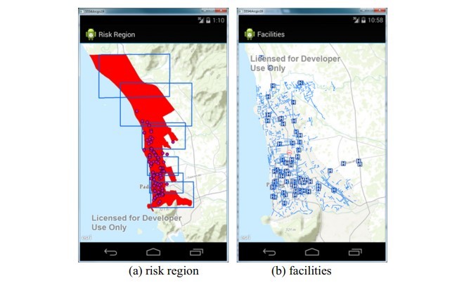
5.1.1. Risk region visualization
5.1.2. Facilities location visualization
5.2. Evacuation route analysis and dissemination
5.2.1. Shelter allocation
5.2.2. Route Finder and dissemination
5.3. Route real-time update
5.3.1. Barrier report
5.3.2. Shelter management
5.3.3. Route update
6. Conclusion
References