
دانلود رایگان مقاله مساله برنامه ریزی حمل و نقل آبی
چکیده
یکی از مهم ترین موضوعات مرتبط با بندر، دسترسی به راه های آبی و مدیریت ترافیک شان است. این مورد، فشار زیادی به طور خاص بر ظرفیت محدود شدۀ راه های حمل و نقل آبی وارد می کند، که عدم استفادۀ کارآمد باعث زیان در رقابت و هم چنین افزایش حجم تولید گازهای گلخانه ای و در نتیجه آلودگی محیط زیست می شود. در این زمینه، مسألۀ برنامه ریزی حمل و نقل آبی، پیشنهاد می شود؛ که هدفش برنامه ریزی ورود و خروج کشتی ها از طریق آبراه های مختلف برای ورود یا ترک بندر به طوری که زمان انتظار حداقل شود، است. از سویی دیگر، این تابع هدف مانع ایجاد گلوگاه یا تراکم از طریق برنامه ریزی ترافیک آبراه می شود و از سوی دیگر، در حالی که کشتی ها در بندر برای ورود یا خروج منتظر هستند گازهای گلخانه ای ناشی از آن ها کاهش می یابد. مدلی ریاضی و ابتکاری پیشنهاد می شود. سناریوهای واقعی برمبنای دلتای یانگ تسه (شانگهای) برای ارزیابی عملکرد الگوریتم ابتکاری و بهبود عملیات در دنیای واقعی ارائه می شود.
1. مقدمه
رشد ترافیک دریایی، اداره کنندگان بندر را مجبور می کرد تا برای کاهش زمان انتظار هنگام دسترسی به زیرساخت هایشان، به طور مؤثری آن ها بخواهند سهم بازارشان را افزایش داده (Verstichel et al., 2011)، و گازهای گلخانه ای کشتی ها را کاهش دهند (کار Du et al.,2011, 2015 را ببینید) که این امر منجر به افزایش گازهای گلخانه ای و آلاینده های مضر و ارتقاء موقعیت بندر در سلسله مراتب بندر از طریق افزایش دسترسی بندر شده است (Caldeirinha and Felício, 2014). در این راستا، همان طور که Notteboom (2006) نشان داد 93.6 درصد برنامه های تأخیر به دلیل دسترسی به بندر و عملیات پایانه است. این ویژگی حتی زمانی که پایانه های کانتینر مانند بندرشانگهای جایی که_ با توجه به تعداد مشارکت کنندگان _ تعداد زیادی کشتی به صورت روزانه برای تعمیر از آبراه یانگ تسه دلتا می گذرند وجود دارد ارزشمندتر می شود. بنابراین، از آن جا که آبراه ها نقش مهمی را در پایانه های کانتینر دریایی (Notteboom, 2008) بازی می کند، آن ها به صورت کارا جهت اجتناب از گلوگاه ها یا ازدحام به دنبال راهی هستند که بتواند جهت زیان ناشی از رقابت به کار روند. به علاوه، استفاده از آبراه های داخلی به عنوان یک حالت حمل و نقل در پایانه های کشتی رانی، زمانی که ادغام فزاینده اش را با دیگر روش های حمل و نقل با چندین برنامۀ حمل شبکه ای در نظر می گیریم (Lowe, 2005, UNESCAP1) آشکارتر می شود. این مورد وجهی را برای مقابله با محدودیت های لجستیکی و فضایی در نظر می گیرد و موضوعاتی مرتبط با بندر را به اقتصاد جهانی اضافه می کند.
از یکسو، از دیدگاه لجستیک سبز، اپراتورهای پایانه به کاهش گازهای گلخانه علاقمند هستند در حالی که به حفظ کیفیت خدمات نیز توجه دارند و از سویی دیگر، شرکت های حمل و نقل به خدمات هموار برای اجتناب از زمان انتظار غیرضروری نیاز دارند به طوری که باعث تأثیر منفی اقتصادی و زیست محیطی مربوط به مصرف سوخت و زمان طی مسیر، می شود. تعدادی از آثار در ادبیات تخصصی، رابطۀ بین زمان انتظار کشتی و گازهای ساطع شده را مطالعه کردند. Du et al. (2011) نشان دادند که زمان انتظار کشتی ها، تأثیر مهمی بر حجم گازهای ساطع شده دارد، به طوری که جریان عملیات می تواند به شرکت های حمل و نقل برای کاهش گازهای گلخانه ای و هم چنین به بندرها برای کنترل آن ها کمک نماید. در همان راستا، Kontovas and Psaraftis (2011) کاهش گازهای ساطع شده در شبکه های کانتینر دریایی را بررسی کردند که نشان می داد یکی از گزینه-های اصلی برای کاهش CO2 انتشار یافته، کاهش زمان انتظار کشتی است. Song (2014) گازهای گلخانه ای ساطع شده (CO2, CH4, N2O, PM10, PM2,5, NOx, SOx, CO and HC) را مطالعه کرد و هزینه های اجتماعی متناظر با آن ها را در بندر یانگشان در جنوب شانگهای چین مطالعه کرد. در کارشان، آن ها زمان انتظار کشتی در لنگرگاه و هم چنین اسکله را به صورت جداگانه برای ارزیابی گازهای گلخانه ای ساطع شده در نظر گرفتند. این نتایج نشان می دهد اگرچه که زمان انتظار در لنگرگاه تأثیر بیشتری نسبت به اسکله دارد، اما هر دو فعالیت منبع ساطع کردن گازهای گلخانه ای هستند. Fagerholt et al. (2010) در زمینۀ مسیرهای حمل و نقل نشان داد که زمان انتظار بیشتر کشتی ها پتانسیل بیشتری نسبت به کاهش افزایش مصرف سوخت دارند؛ این بر اهمیت زمان انتظار جهت مصرف و ساطع کردن گازهای گلخانه ای تأکید دارد. بنابراین، بهبود دسترسی به آبراه با اجتناب از زمان انتظار غیرضروری در ورودشان می تواند تنها منجر به صرفه جویی هزینه های اجتماعی و عملیاتی شود اما سطح کیفیت زیست محیطی در حداقل کردن گازهای ساطع شده، را افزایش می دهد.
در برنامه ریزی ها همواره تأخیر حمل و نقل دریایی برای دسترسی به بندر، بهره وری پایانه و به طور خاص در پایانه-های همراه با ازدحام اثرگذار خواهد بود، به طوری که تأثیر زیادی به وسیلۀ دسترسی به عملیات مرتبط با راه های آبی خواهد داشت. به طور عمومی، آبراه می تواند به عنوان یک مسیر محدود پر شده با آب تعریف شود، یعنی مسیری با رودخانه های داخلی، دریاچه ها یا خلیج هایی که قابل کشتیرانی هستند. یک آبراه معمولی از آب های با قابلیت کشتیرانی، کمک های ناوبری و شرایط آبی تشکیل شده است. اغلب آبراه های طبیعی هم چنین آبراه های مصنوعی می توانند به عنوان ظرفیت راه های حمل و نقل محدود شده، بسته به ویژگی های خاصشان، ارجاع داده شود. آن ها باید چندین شرط را تأمین کنند به طوری که به کشتی ها خدمت رسانی کنند. اول از همه، یک آبراه واجد شرایط باید عمق کافی داشته باشد. دوم این که، عرض آبراه یک معیار بسیار مهمی است. معمولاً یک آبراه، دو طرفه است و عرض آن باید بیش از مجموع وسعت دو کشتی در جهت مخالف با عرض اضافی به دلیل ایمنی باشد، اما بعضی اوقات تنها یک کشتی می تواند از آن عبور کند.
فقط تعداد کمی بر توجه به برنامه ریزی آبراه تمرکز دارد. Dai and Schonfeld (1998)، به تخمین تأخیرات آبراه با استفاده از متامدل و نظریۀ صف پرداختند. Taylor et al. (2005) سیستمی نرم افزاری را برمبنای شبیه سازی برای اعزام باربری کوچک و تخصیص قایق در آبراه داخلی توسعه دادند. تعدادی از آثار دیگر، به بررسی استفاده از قفل پرداخته اند. Smith et al. (2009) آبراه Upper Mississippi River را بررسی کردند. این آبراه داخلی اصلی با 29 قفل است. آن ها مدل شبیه سازی شدۀ گسسته ای را به عنوان روش مناسب برای بهبود استراتژی ورود- اول، خدمات- اول استفاده کردند. Smith et al. (2011) قوانین تصمیم گیری پیچیده ای را براساس یک برنامه زمان بندی پیچیده و مسألۀ یکپارچه ای را برای بهبود عملکرد قفل پیشنهاد دادند. Verstichel et al. (2014) موقعیت کشتی ها را در حفره ها مطالعه کردند؛ آن ها فرمول بندی ریاضی و رویکرد حلی برای آن ارائه کردند. کارهای دیگر بر توجه شان بر برنامه ریزی عبور و مرور در کانال تمرکز دارد. Günther et al. (2010, 2011) بر عبور و مرور دو طرفۀ کشتی در کانال کیل پرداختند. آن ها کانال را به عنوان مجموعه ای دیگر از بخش های کانال و کناره گیری در نظر گرفتند. آن ها فرمول ریاضی برای طراحی مسیر خطی و حمل و نقل شبکه ای ارائه کردند. هدف مدل شان حداقل کردن زمان کل مسیر کشتی ها است این زمان شامل قفل کردن و زمان انتظار برای کناره گیری می باشد. Yang et al. (2014) مدل برنامه ریزی عدد صحیحی را برای بهینه کردن شبکۀ خطی رودخانۀ یانگ تسه ارائه کردند. آن ها یانگ تسه محدوده شده را تنها با یک کانال آب نسبت به گزینه های دیگر و تمام صف بندرها در کنار آب را در نظر گرفتند. رویکردشان به کاهش هزینه های حمل و نقل کمک می کند به طوری که هزینه های عملیات و سوخت در مسیر انتخاب شده کاهش یابند. آن ها همان عملیات مشابه را در هر بندر در نظر گرفتند. Ulusçu et al. (2009) ترافیک را در تنگۀ استانبول مطالعه کردند و الگوریتم را برای برنامه-ریزی کشتی های وارده با ملاحظات خاص به تنگه توسعه دادند.
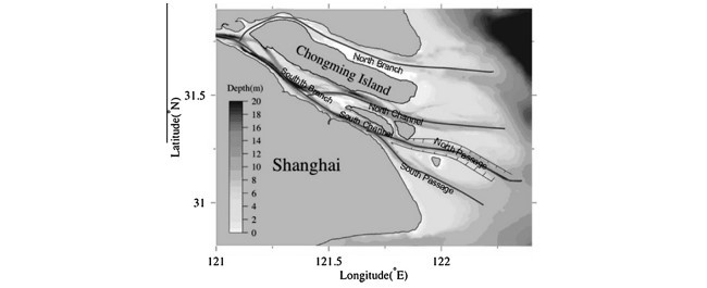
با این وجود این واقعیت که در مرور ادبیات مرتبط یک یا چند مسألۀ برنامه ریزی آبراه در نظر گرفته شده است، رویکردهای پیشنهادی به موارد خاصی که به آبراه های مطالعه شده یا مسیرهای طراحی شده برای بازدید از پایانه-های در طول آن ها محدود شده است. در این راستا، در این کار، هدف ما، نشان دادن یک روش عمومی برای پرداختن به برنامه ریزی عبور و مرور در طول آبراه ها است. علاوه بر این، هم چنین این مفهوم به ما اجازه می دهد تا به سناریوی حمل و نقل خاصی بپردازیم که در آبراه های ورودی در بندر شانگهای (چین) اتفاق می افتد. آبراه ورودی، یک آبراهی است که دریا یا رودخانۀ اصلی ورودی را و آب بندر را به یکدیگر متصل می سازد. به طور گسترده، اذعان می کند که یک معیار برای انتخاب بندر، ارتباطش است و این که می تواند به روش ساده ای با استفاده از عمق آب عملیاتی شود. با این وجود، اگر یک بندر آبراه ورودی با شرایط عمق خوب و عرض مناسب نداشته باشد، کشتی ها با درفت بزرگ نمی توانند وارد شوند مهم نیست عمق اسکله چقدر است. به همین دلیل آبراه ورودی مهم ترین قسمت جهت برقراری ارتباط است. برای مثال، دهانۀ آبراه عمیق یانگ تسه به عنوان ورودی اصلی بندر شانگهای به سه پروژۀ نظارتی در مقیاس بزرگ و پیچیده تبدیل شد. مسیر اصلی 7 متر (1998) بود که به طور جدی با توسعۀ صنعت حمل و نقل شانگهای محدود شده بود. در نهایت، عمق آن به 12. متر (2010) رسید که اجازۀ عبور پنجمین و ششمین نسل کانتینر را می دهد.
بحث قبلی به وضوح اهمیت اقتصادی، عملیاتی و محیط زیست را نشان می دهد که برنامه ریزی کشتی ها در امتداد آبراه دارد. این امر منجر به نیاز به مدل های ریاضی و رویکرد های حل آن می شود. با این هدف ذهنی، نوآوری های اصلی این مقاله عبارتند از:
- مسألۀ برنامه ریزی حمل و نقل آبی (WSSP) را به منظور برنامه ریزی حمل و نقل در مسیر آبراه ها پیشنهاد شد. این مسأله به صورت برنامه ریزی خطی مختلط عدد صحیح (MILP) و با در نظر گرفتن موقعیت واقعی در یانگ تسه، شانگهای، مدل شد. در این راستا، بررسی در گروه بین المللی بندر شانگهای (SIPG) انجام شد، تعداد زیادی از کشتی ها هر روز از این آبراه عبور می کنند و نسبت زیادی از آن ها نمی توانند در زمان مناسب عبور کنند نه به دلیل محدودیت های جغرافیای یانگ تسه بلکه به دلیل درفت، وسعت و جهت یابی در شب.
- همان طور که Kontovas and Psaraftis (2011) نشان دادند سیاست های مشترکی در پایانه ها برای کاهش زمان انتظار کشتی و در نتیجه کاهش گازهای گلخانه ای استفاده شد. بنابراین، ما الگوریتم های ابتکاری را ارزیابی کرده و برمبنای سیاست های مشتری که در پایانه های کشتی های کانتینر استفاده می شود توسعه دادیم. این امر به ما اجازه می دهد تا بهبود عملیاتی و زیست محیطی را با استفاده از کاهش زمان انتظار که می تواند با استفاده از تکنیک های پیچیده تر مانند شبیه سازی تبرید (SA) در این کار پیشنهاد می شود به دست آورد. در این حالت، SA پیشنهاد داده شده، اجازه می دهد تا گازهای گلخانه ای غیرضروری ایجاد شده توسط زمان انتظار کشتی ها کاهش یابد. علاوه بر این، مقایسه با مدل اجرا شده در CPLEX و الگوریتم های ابتکاری نشان می دهند که SA قادر است تا برنامه هایی با کیفیت بالا ارائه دهد که به عنوان بخشی از سیستم پشتیبان تصمیم گیری (DSS) استفاده شوند. در این کاربرد واقعی، DSS برای تأیید تمام کشتی ها و بهبود زمان انتسابشان استفاده می شود.
- یک مقیاس مناسب برمبنای داده های ارائه شده به وسیلۀ پایانۀ کشتی کانتینر وایگاوکیو (شانگهای) ارائه شد. از سوی دیگر، چون این مسأله می تواند به به سناریوهای دیگر ترجمه شود، این معیار، مسألۀ دیگری از ابعاد مختلف را شامل می شود.
ادامۀ این مقاله به صورت زیر سازمان دهی می شود. بخش 2 ویژگی های خاص یانگ تسه را معرفی می کند. فرمول-بندی ریاضی مسألۀ برنامه ریزی حمل و نقل آبی در بخش 3 ارائه می شود. در بخش 4، روش های حل برای حل این مسأله پیشنهاد شده است. پس از آن در بخش 5، عملکرد هدفمان در سناریوهای واقعی تحلیل می شود. در نهایت، بخش 6 نتایج اصلی که از کار ما به دست آمده را ارائه می کند و چندین پیشنهاد برای کارهای آتی دارد.
Abstract
One of the most important issues in port connectivity refers to the availability of accessible waterways and their traffic management. This puts a lot of pressure especially into capacity restricted transport corridors, where their inefficient use may not only result in a loss of the port competitiveness but also in an increase of the volume of ship emissions polluting the environment. In this context, the Waterway Ship Scheduling Problem is proposed; its goal is to schedule incoming and outgoing ships through different waterways for accessing or leaving the port in such a way that the ships’ waiting time is minimized. This objective allows, on the one hand, to avoid bottlenecks or congestions through scheduling the waterway traffic, and on the other hand, reduce vessel emissions while they are waiting at the anchorage either for entering or leaving. A mathematical model and heuristics are proposed. Real scenarios based on the Yangtze Delta (Shanghai) are tackled for assessing the performance of the heuristic and the improvement upon real-world terminal operations.
1. Introduction
The maritime traffic growth forces port operators to efficiently reduce the ships’ waiting time when accessing their infrastructures if they want to increase or maintain their market share (Verstichel et al., 2011), reduce ship emissions (see Du et al., 2011, 2015) that contribute to increase greenhouse gases and harmful pollutants, and upgrade the port position in the port hierarchy through enhancing the port accessibility (Caldeirinha and Felício, 2014). In this regard, as indicated by Notteboom (2006), 93.6% of the delayed schedules are attributable to port access and terminal operations. This characteristic becomes even more relevant at some container terminals like in the port of Shanghai, where – according to practitioners – there is a multitude of ships daily requiring to pass through the Yangtze Delta waterways. Therefore, since the waterways play an important role at some maritime container terminals (Notteboom, 2008), it is sought to efficiently use them in order to avoid bottlenecks or congestions that may be translated into a loss of competitiveness. Moreover, the use of inland waterways as a transportation mode at container terminals is becoming even more relevant when we consider its increasing integration with other transport modes within multi-mode freight network schemes (Lowe, 2005, UNESCAP1 ). This close intermodality pursues to cope with the spatial or logistic restrictions that appear at some container terminals and it adds to the issues to be dealt with in port connectivity in the globalized economy.
From a green-logistics standpoint, on the one side, terminal operators are interested in reducing ship emissions while maintaining the quality of the service and, on the other side, shipping companies require smooth services to avoid unnecessary waiting times that cause a negative economic and environmental impact related to fuel consumption and route timing. Some works in the specialized literature have studied the relationship between the ships’ waiting time and their emissions. Du et al. (2011) indicate that the waiting time of the ships has an important influence on the volume emissions, where having flowing operations can help shipping companies to reduce emissions as well as help ports to have control over that. In the same line the work by Kontovas and Psaraftis (2011) investigates the reduction of emissions in maritime intermodal container networks, indicating that one of the main alternatives to reduce CO2 emissions is related to the reduction of the vessel waiting time. Song (2014) studies the ship emissions inventory (CO2, CH4, N2O, PM10, PM2,5, NOx, SOx, CO and HC) and their associated social cost in the Yangshan port at the south of Shanghai (China). In their work they include the waiting of the ship at the anchorage as well as at the berth as segments for evaluating the ship emissions. Their results show that although waiting at the berth has a greater impact than waiting at the anchorage, both activity modes result in sources of emissions. Fagerholt et al. (2010) in the context of shipping routes indicated that the more vessels’ waiting time the more the potential to reduce fuel consumption increases; this highlights the importance that waiting times have on consumption and emissions. Therefore, improving the waterway access operations by avoiding unnecessary waiting time at their entrance may lead not only to operational and social cost savings but also to an enhancement of the level of environmental quality of service through minimizing emissions.
In maritime shipping delayed schedules attributable to port access affect terminal productivity especially at some highcongested terminals, that are largely influenced by port access operations related to waterways. To be generic, a waterway can be defined as a capacity restricted transport corridor filled with water, e.g., a passage within inland rivers, lakes or bays which are navigable. A typical waterway consists of navigable waters, navigational aids and water conditions. Often natural as well as artificial waterways may be referred to as capacity restricted transport corridors, depending on their specific characteristics. They have to meet several conditions so as to serve the ships. First of all, an eligible waterway should provide sufficient depth. Secondly, the width of the waterway is also a crucial criterion. Usually, a waterway is two-directional and its width should exceed the sum of the breadth of the two navigating ships at the opposite direction with additional abundant width for the sake of safety, but occasionally it just refers to the isolated passing of individual vessels.
Only a few works focus their attention on waterway scheduling. Dai and Schonfeld (1998) discuss the estimation of waterway delays using metamodels and queuing theory. Taylor et al. (2005) develop a simulation-based software system for barge dispatching and boat assignment in an inland waterway. Some other works are more related to the use of locks. Smith et al. (2009) analyse the Upper Mississippi River waterway. This is a major inland waterway that includes 29 locks. They present a discrete simulation model as a suitable procedure for improving the practice prevailing first-come firstserved strategy used. Smith et al. (2011) propose complex decision rules based on a heuristic scheduler and a mathematical integer problem for improving the performance of the locks. Verstichel et al. (2014) study the positioning of the ships into lock chambers; they present a mathematical formulation and a solution approach for solving it. Other works focus their attention on the traffic planning on canals. Günther et al. (2010, 2011) deal with the bidirectional ship traffic on the Kiel Canal. They consider the canal as an alternating collection of canal segments and sidings. They present a mathematical formulation for designing the liner route and shipping networks. The aim of their model is to minimize the total passage time of ships, where this time includes the lock and siding waiting times. Yang et al. (2014) present an integer programming model to optimize the container liner network on the Yangtze River. They consider the Yangtze constrained only to a single water channel rather than several alternatives and all ports queue alongside the waterway. Their approach aims to reduce the transportation costs, that are the operation and fuel costs of the selected route. They consider the same operation times in each port. Ulusçu et al. (2009) study the traffic along the Istanbul Strait and develop an algorithm for scheduling the incoming ships for the specific considerations of the strait.
Despite the fact that in the related literature some works address one or the other waterway scheduling problem, the proposed approaches are restricted to the specifications of the studied waterways or designing the routes for visiting terminals along them. In this regard, in this work one of our goals is to present a more general approach for addressing the scheduling of the traffic along the waterways. Moreover, this concept also allows us to address the specific logistic scenario that takes place at the entering waterways of the Shanghai Port (China).2 An entrance waterway is one kind of waterway that connects a sea or inland river main waterway and the harbour water. It is widely acknowledged that one of the criteria to judge a port is its connectivity and it may be operationalized in a simplified way by means of its water depth. However, if one port does not have an entrance waterway with good depth and width condition, ships with large draft still cannot enter no matter how deep the berth-side is. That is why an entrance waterway is of great importance regarding connectivity. For example, the Yangtze Estuary Deep-water waterway as a main entrance of Shanghai port went through three complex and large-scale regulatory projects. Its original depth was 7 m (1998) which seriously restricted the development of the Shanghai shipping industry. Finally it reached a depth of 12.5 m (2010) which permits the passing of the fifth and the sixth generation of maritime container ships.
The previous discussions clearly draw the economical, operational, and environmental importance that scheduling ships along waterways has. This leads to the need of mathematical models and solution approaches for appropriately addressing this issue. With this goal in mind, the main contributions of this paper are:
– Propose the Waterway Ship Scheduling Problem (WSSP) in order to address the ship scheduling along waterways. This problem is modelled as Mixed Integer Linear Program (MILP) and addressed considering the real-situation taking place at the Yangtze Estuary, Shanghai. In this regard, according to a survey conducted with the Shanghai International Port Group (SIPG), there is a large number of ships applying to pass the waterway per day and a great proportion of them fails to apply for the appropriate time of passing, because of not considering the geographic constraints of the Yangtze Estuary such as draft, breadth and night navigation.
– As Kontovas and Psaraftis (2011) indicate there are common policies used in terminals for reducing the ships’ waiting time and, consequently, emissions. Therefore, we develop and assess heuristics based on some common policies used at container terminals. This allows to evaluate the operational and environmental improvement by means of the reduction of the waiting time that can be obtained through the use of more sophisticated techniques such as the simulated annealing (SA) proposed in this work. In this sense, the proposed SA approaches allow to reduce the unnecessary emissions generated during the ships’ waiting time. In addition, the comparison with the model implemented in CPLEX and the heuristics shows that the SA is able to provide high-quality schedules which justify its use as part of a decision support system (DSS). In this real application, the DSS would be used for verifying all the ships and modify their time assignments.
– Provide a benchmark suite based on data provided by the container terminal of Waigaoqiao (Shanghai). On the other hand, since this problem can be translated to other scenarios, the benchmark suite includes other problem instances of different dimensions.
The remainder of this paper is organized as follows. Section 2 introduces specific characteristics of the Yangtze Estuary. The mathematical formulation of the Waterway Ship Scheduling Problem is presented in Section 3. In Section 4, the solution approaches proposed for solving this problem are depicted. Afterwards, Section 5 analyses the performance of our proposal in realistic scenarios. Finally, Section 6 provides our main conclusions extracted from the work and suggests several directions for further research.
چکیده
1. مقدمه
2. حوزۀ مطالعاتی: رود یانگ تسه
2.1 تنظیمات پایه
2.2 تأثیر جزر و مدی
3. فرموله کردن مسأله
4. مدل های حل برای WSSP
4.1 الگوریتم حریصانه
4.2 شبیه سازی تبرید
5. آزمایش های محاسباتی
5.1 نسل مسأله
5.2 مقایسۀ بین الگوریتم های ابتکاری
5.3 برنامه ریزی ریاضی و نتایج الگوریتم های ابتکاری و بحث
6. نتیجه گیری و تحقیق بیشتر
منابع
Abstract
1. Introduction
2. Study area: Yangtze Estuary
2.1. Basic settings
2.2. Tidal impact
3. Problem formulation
4. Solution methods for the WSSP
4.1. Greedy heuristics
4.2. Simulated annealing
5. Computational experiments
5.1. Problem generation
5.2. Comparison among heuristics
5.3. Mathematical programming and metaheuristics results and discussion
6. Conclusions and further research
References