
دانلود رایگان مقاله تنظیم زمین ساختی از دریاچه برم فیروز
چکیده
این مقاله، نقش فرآیندهای زمین ساختی و کارستیک در شکل گیری و تکامل دریاچه Barm Firuz در کوه های زاگرس ایران را ارائه می دهد. این دریاچه با ارتفاع 3340 متر از سطح دریا در تاج تاقدیس Barm Friuz واقع شده است. نتایج نشان می دهد که تکامل ساختاری دریاچه Barme Firuz مربوط به هر دو فرایند های زمین ساختی و کارست (رسوبی سنگ آهک) است. بنابراین عبارت زمین ساختی کارستیک برای تکامل ساختاری دریاچه استفاده شده است. مطالعات سازه ای به ویژه در مورد ساختارهای ستون سنگی (ستون سنگي همجنس صخره متصل بخود) وقوع یک جزء مهم از تغییر شکل برشی ساده را در منطقه مورد مطالعه نشان داد. بر اساس شواهد ساختاری و کارستیک در اطراف دریاچه، مدل فرونشستن انحلال-گسل با جزء مورب برشی خالص به عنوان مدل حرکتی از تکامل دریاچه Barm Firuz در کوه های زاگرس ایران پیشنهاد شده است.
0. مقدمه
منجلاب ها توسط انحلال سازندهای کربناتی توسط نفوذ سطحی و آبهای زیرزمینی و فروپاشی سنگ ها به دلیل نیروی گرانش (Filipponi و همکاران، 2009) تشکیل می شوند. در بسیاری از موارد، اثرات زمین ساختی برای افزایش چگالی شکستگی ها برای تکامل ویژگی های کارست بسیار مهم است. بنابراین ویژگی های زمین ساختی می تواند به عنوان پدیده مکمل برای تشکیل ویژگی های کارست عمل نماید. گاهی اوقات یک شوک زمین ساختی از جمله زلزله، نیروی محرکه ای را برای تکان خوردن سنگ ها تولید می نماید. به هر حال، نقش آب در تولید حفره های کارست مهم ترین عامل است. به طوری که در بسیاری از موارد، مستقل از اثرات زمین ساختی و تنها با بهره برداری از آب اسیدی تشکیل یک منجلاب کارست امکان پذیر است. اما در برخی از موارد شواهدی از اثرات زمین ساختی را می توان در سراسر منجلاب ها (Neal، 2004) دید. در چنین مواردی، شرایط منجلاب ها تکنوکراستیک می توانند مورد استفاده قرار گیرند. تعیین تقدم و تاخر انحلال و یا عملیات زمین ساختی در تشکیل منجلاب ها بسیار دشوار است و گاهی اوقات عمل همزمان این دو پدیده به یک منجلاب تکنوکراستیک شکل می دهند. بسیاری از ساختارهای تکنوکراستیک در جهان وجود دارند. San Gregorio در Magno و Dasht Arjan در ایتالیا و ایران نمونه هایی از دو ویژگی شناخته شده تکنوکراستیک هستند. این کار به بررسی اهمیت تجزیه و تحلیل ساختاری در توصیف فرآیندهای زمین ساختی و کارستیک در تکامل دریاچه Barm Firuz می پردازد.
1. تنظیم زمین شناسی منطقه ای
کمربند چین خوردگی-محوری زاگرس بخشی از کمربند کوهزایی آلپ-هیمالیا (Berberian و King، 1981) است و در حاشیه شمال شرقی صفحه عربستان قرار گرفته است. این کمربند شامل ردیف Cambrian-اخیر حاوی 8-14 کیلومتر ضخامت می شود که در طبقه زیرزمین Precambrian قرار می گیرد. این رسوبات روی یک پلت فرم واقع بودند که تا زمان برخورد بین صفحات عربستان و ایرانی در اواخر کرتاسه تا دوران ترشیاری نسبتا از Cambrian پایدارتر بودند(Berberian و King، 1981؛ Falcon، 1974). کوتاه شدن در سراسر کمربند چین خوردگی-محوری زاگرس در پوشش سنگ پیدازیستی، که تخمین زده می شود حدود 30-85 کیلومتر باشد (McQuarrie، 2004؛ Blanc و همکاران، 2003؛. Falcon، 1974)، توسط فشار محوری و چین خوردگی بالای کران های مختلف لغزندگی صخره های مجاور رخ داد. کوتاه شدن پوسته پس از برخورد (Allen و همکاران، 2004؛.. Tatar و همکاران، 2004؛ Talebian و Jackson، 2002؛ Jackson و McKenzie، 1984) با نرخ همگرایی N-S جهت یافته از حدود 2 ± 20 هنوز هم فعال است (Molinaro و همکاران، 2005؛.. Vernant و همکاران، 2004). کوتاه شدن در طبقه زیرزمین غالباً توسط گسل رخ می دهد. Cambrian Hormuz Salt ضخیم، در پایه جانشینی رسوبی، و دیگر کران های تبخیر (به عنوان مثال، سازندهای Dashtak و Gachsaran) در جانشینی (Sepehr و Cosgrove، 2005؛ Talebian و Jackson، 2002)، مانع از این شد که گسل های طبقه زیرزمین، سنگ های پوششی را گسسته نمایند و به سطح برسند. به عنوان یک نتیجه از این کران های تجزیه کننده، تغییر شکل در زیرزمین و پوشش رسوبی به طور مستقل رخ داد. این کمربند چین خوردگی-محوری حدوداً 1800 کیلومتر طول و 200-300 کیلومتر عرض دارد. از از شرق ترکیه تا تنگه هرمز است، که در روبروی گسل میناب پایان می یابد (شکل 1)، که کمربند زاگرس را از منشور به هم پیوسته Makran جدا می کند (Molinaro و همکاران، 2005). منطقه مورد مطالعه در تاقدیس Barm Friuz در نزدیکی شهر اردکان 110 کیلومتر شمال غرب شیراز واقع شده است.تاقدیس Barm Friuz همانند تاقدیس های بسیاری در کمربند چین خوردگی-محوری زاگرس نشان دهنده روند محوری با جهت گیری NW-SE است. تاقدیس، هندسه غوطه وری مضاعف را نشان می دهد. بخش اصلی این تاقدیس شامل سازند Cretaceous Sarvak تشکیل شده عمدتا از سنگ های کربناتی است که یکی از سنگ های اصلی هیدروکربن در جنوب غربی ایران است. در منطقه مورد مطالعه، شامل سازند Sravak شامل سنگ آهک سبک تا خاکستری برش آهکی و بستریافته متوسط. نمودارهای 2 و 3 نشان دهنده تصویر ماهواره ای مایل و نقشه زمین شناسی منطقه مورد مطالعه است.
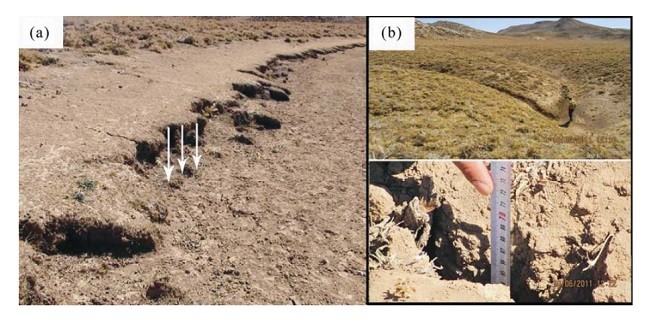
2. شواهد سازه ای و کارستیک
به علت موقعیت منحصر به فرد از دریاچه Barm Firuz، این موضوع علاقه برای بسیاری از زمین شناسان است. چند مطالعه هیدروژئولوژیک روی دریاچه (Eftekhari، 1993؛ Pezeshkour، 1991) انجام شده است. این مطالعات به طور عمده روی روابط هیدرولوژیکی از دریاچه با بوته های کوچک در سراسر تاقدیس Barm Friuz متمرکز شده است. در این تحقیق یک مدل حرکتی می تواند برای تکامل دریاچه Barm Firuz با استفاده از ساختارهای ستون سنگی مورد بررسی قرار گیرد. تجزیه و تحلیل و تشخیص تصاویر ماهواره ای عناصر خطی نشان دهنده چندین سیستم گسل اصلی در اطراف دریاچه است. به نظر می رسد که این دو سیستم گسل در این منطقه غالب هستند. گسل ها با روند موازی و گسل ها با نگرش 30 تا 40 درجه نسبت به محور چین خوردگی Barm Friuz Anticline (شکل 4). مرتبط با گسل ها، اجزای حرکت عمودی در امتداد محور طولی دریاچه به خصوص در لبه جنوبی، منطقه دریاچه به عنوان یک منطقه با ارتفاع کم بین صفحات گسل مشخص شد (شکل a5، 5b). سطوح برش عمودی سنگ آهک در اطراف دریاچه نشان دهنده بسیاری از حفره های انحلال، karrens و ویژگی های گسل صيقلي صخره می باشند. در برخی از موارد صفحات گسل نشان دهنده یک سطح صاف با لغزش خراشی مشخص و در مکان های دیگر یک سطح خشن و انحلال را نشان می دهند. فیبرهای صخره های صیقلی روی صفحات گسل عمدتا نشان دهنده زاویه غوطه وری بالا است که غلبه حرکت عمودی در صفحات گسل را تایید می نماید. همانطور که در بالا اشاره شد، ویژگی های کارن در سطوح کربنات در اطراف دریاچه شکل گرفته است.
این شیارهای انحلال به طور عمده دارای حالت عمودی هستند و در تمام سطوح کربنات قابل مشاهده نیستند، بنابراین می توان استنباط نمود که گسل ها و پیوستگی های عمودی، نقش مهمی در کنترل جهت جریان آب بازی کرده اند. حرکات گسل جوان باعث شده است که شیارهای کارستیک قطع شود و سطوح کربنات با هر دو ویژگی های کارن و سطح صیقلی صخره تشکیل شود (شکل 6).
ABSTRACT
This paper presents the role of tectonic and karstic processes in the formation and evolution of Barm Firuz Lake within the Zagros Mountains of Iran. This lake with elevation of 3 340 m from sea level is located in the crest of the Barm Firuz anticline. Results show that the structural evolution of the Barme Firuz Lake is related to both tectonic and karst processes. Therefore the term of tectonokarstic has been used for structural evolution of the lake. Structural studies especially on the stylolite structures revealed the occurrence of an important component of simple shear deformation in the study area. Based on structural and karstic evidence around the lake, the fault-dissolution sink model with oblique pure shear component is suggested as kinematic model of the Barm Firuz Lake evolution in the Zagros Mountains of Iran.
0 INTRODUCTION
Sinkholes form by dissolution of carbonate formations by influence of surface and underground waters and rocks collapse due to gravity force (Filipponi et al., 2009). In many cases the effects of tectonics for increase of fractures density is very important for evolution of karst features. Therefore tectonics can be act as complementary phenomenon for formation of karst features. Sometimes a tectonic shock such as earthquake generates driving force for tumble down of the rocks. Anyway, the role of water in generate of karst cavities is the most important factor. So that in many cases, independent of the tectonic effects and only with operation of acidic water the formation of a karst sinkhole is possible. But in some cases the evidence of tectonic effects can be seen around the sinkholes (Neal, 2004). In such cases the terms of tectonokarstic sinkholes can be used. Determination of transposition of dissolution or tectonic operation in the formation of sinkholes is very difficult and sometimes simultaneous operation of these two phenomena forms a tectonokarstic sinkhole. There are many tectonokarstic structures in the world. San Gregorio Magno and Dasht Arjan in Italy and Iran are the examples of two known tectonokarstic features. This work investigates the importance of structural analyses in the characterizing of tectonic and karstic processes on the evolution of the Barm Firuz Lake.
1 REGIONAL GEOLOGICAL SETTING
The Zagros fold-thrust belt is part of the AlpineHimalayan orogenic belt (Berberian and King, 1981) and lies on the northeastern margin of the Arabian Plate. This belt contains 8–14 km thick Cambrian–recent succession, which lie on a Precambrian basement. These sediments were deposited on a platform that was relatively stable from the Cambrian until the collision between the Arabian and Iranian plates in the Late Cretaceous to Tertiary (Berberian and King, 1981; Falcon, 1974). Shortening across the Zagros fold-thrust belt in the Phanerozoic rock cover, which is estimated to be about 30–85 km (McQuarrie, 2004; Blanc et al., 2003; Falcon, 1974), occurred by thrusting and folding above various decollement horizons. Postcollisional crustal shortening is still active (Allen et al., 2004; Tatar et al., 2004; Talebian and Jackson, 2002; Jackson and McKenzie, 1984) with an N-S oriented convergence rate of approximately 20±2 mmyr-1 (Molinaro et al., 2005; Vernant et al., 2004). Shortening in the basement occurs dominantly by faulting. The thick Cambrian Hormuz Salt, at the base of the sedimentary succession, and other evaporite horizons (e.g., the Dashtak and Gachsaran formations) within the succession (Sepehr and Cosgrove, 2005; Talebian and Jackson, 2002), prevented these basement faults from rupturing the cover rocks and reaching the surface. As a result of these decoupling horizons, the deformation in the basement and the sedimentary cover occurred independently. This fold-thrust belt is approximately 1 800 km long and 200–300 km wide. It runs from eastern Turkey to the Strait of Hormuz, where it terminates against the Minab fault (Fig. 1), which separates the Zagros belt from the Makran accretionary prism (Molinaro et al., 2005). The study area is located in the Barm Firuz anticline near Ardekan Town 110 km northwestern of Shiraz. The Barm Firuz anticline such as many anticlines in the Zagros fold-thrust belt shows an axial trend with NW-SE orientation. The anticline shows doubly plunging geometry. The main part of this anticline consist of the Cretaceous Sarvak Formation composed mainly of carbonate rocks that is one of the main hydrocarbon reservoir rocks in Southwest Iran. In the study area, the Sarvak Formation consists of light to grey calcareous breccia and medium bedded limestone. Figures 2 and 3 show the oblique satellite image and the geological map of the study area.
2 STRUCTURAL AND KARSTIC EVIDENCE
Because of the unique position of the Barm Firuz Lake it is interest subject for many geologists. Several hydrogeological studies have been done on the lake (Eftekhari, 1993; Pezeshkour, 1991). These studies mainly concentrated on the hydrological relationships of the lake with the sprigs around the Barm Firuz anticline. In this research a possible kinematic model for the evolution of the Barm Firuz Lake is investigated using stylolite structures. Satellite images analyses and detection of linear elements show several main fault systems around the lake. It seems that two fault systems dominated in the area. Faults with parallel trend and faults with attitude of 30° to 40° in respect of the fold axis of the Barm Firuz Anticline (Fig. 4). Related to the faults vertical movement components along the long axis of the lake especially in the south rim, the lake area identified as a low elevation between the fault planes (Figs. 5a, 5b). Limestone scarp surfaces around the lake show numerous of dissolution cavities, karrens and fault slickensides features. In some cases the fault planes show a smooth surface with clear scratch-slip and in another places exhibit a rough and dissolution surface. Slickenfibres on the fault planes mainly show high plunge angles which confirm predominant of vertical movement on the fault planes. As mentioned above, karren features have formed on the carbonate surfaces around the lake.
These dissolution grooves mainly have vertical mode and no visible on the all of carbonate surfaces so it can be deduced that vertical faults and joints have played an important role to control of the water flow directions. Young fault movements have caused to cut karstic grooves and formed carbonate surfaces with both karren and slickenside features (Fig. 6).
چکیده
0. مقدمه
1. تنظیم زمین شناسی منطقه ای
2. شواهد سازه ای و کارستیک
3. بحث
4. نتیجه گیری
ABSTRACT
0 INTRODUCTION
1 REGIONAL GEOLOGICAL SETTING
2 STRUCTURAL AND KARSTIC EVIDENCE
3 DISCUSSION
4 CONCLUSION