دانلود رایگان تحقیق انگلیسی موقعیت تاریخی و جغرافیایی ایران با ترجمه فارسی
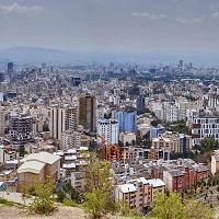
ایران، کشوری کوهستانی، خشک و دارای تنوع قومیتی در جنوب غربی آسیا است. بخش اعظم ایران از یک فلات کویری مرکزی تشکیل شده است که از هر طرف با رشته کوه های مرتفع احاطه شده است که امکان دسترسی به داخل کشور را از طریق گردنه های مرتفع فراهم می کند. پایتخت این کشور تهران، یک کلان شهر شلوغ در دامنه جنوبی کوه های البرز است. این شهر که به خاطر معماری زیبا و باغهای سرسبزش شهرت دارد، در دهه های پس از انقلاب 1978-1979 ایران تا حدودی رو به ویرانی رفت، اگرچه بعداً تلاشهایی برای حفظ ساختمان های تاریخی و گسترش شبکه پارک های شهر انجام شد. تهران و شهرهایی مانند اصفهان و شیراز ساختمان های مدرن را با بناهای مهم گذشته ترکیب میکنند و به عنوان مراکز اصلی آموزش، فرهنگ و تجارت عمل میکنند.
قلب امپراتوری حکایت ایران در دوران باستان، از دیرباز به عنوان یک قدرت پادشاهی و بعدها به دلیل موقعیت استراتژیک و منابع طبیعی فراوان، به ویژه نفت، بهعنوان عاملی در رقابت های استعماری و ابرقدرتها، نقش مهمی را ایفا کرده است. ریشه این کشور به عنوان یک فرهنگ و جامعه متمایز به دوره هخامنشیان می رسد که در سال 550 قبل از میلاد آغاز شد. از آن زمان منطقه ای که ایران کنونی نامیده می شود – و به طور سنتی پرشیا نامیده می شود – تحت تأثیر امواج فاتحان و مهاجران بومی و خارجی از جمله امپراتوری سلوکیان و اشکانیان و ساسانیان بومی بوده است. با این حال، فتح ایران توسط اعراب مسلمان در قرن هفتم پس از میلاد، ماندگارترین تأثیر را از خود برجای گذاشت، زیرا فرهنگ ایرانی کاملاً تحت تأثیر فرهنگ فاتحان آن بود.
رنسانس فرهنگی ایرانیان در اواخر قرن هشتم منجر به بیداری مجدد فرهنگ ادبی فارسی شد، اگرچه زبان فارسی به شدت به زبان عربی و به خط عربی تبدیل شده بود و سلسلههای اسلامی ایرانی بومی با ظهور طاهریان در اوایل قرن نهم شروع به ظهور کردند. این منطقه تحت سیطره امواج متوالی فاتحان ایرانی، ترک و مغول قرار گرفت تا اینکه در اوایل قرن شانزدهم، صفویان که تشیع دوازده امامی را به عنوان مرام رسمی معرفی کردند، ظهور کردند. در طول قرنهای بعد، با ظهور روحانیون شیعه مستقر توسط دولت، ترکیبی بین فرهنگ ایرانی و اسلام شیعی شکل گرفت که هر یک را به طور ماندگاری با رنگ دیگری مشخص کرد.
با سقوط صفویان در سال 1736، حکومت به دست چندین سلسله کوتاه مدت رسید که منجر به ظهور قاجار در سال 1796 شد. حکومت قاجار با نفوذ روزافزون قدرت های اروپایی در امور داخلی و مشکلات اقتصادی و سیاسی ناشی از آن و قدرت روزافزون روحانیت شیعه در مسائل اجتماعی و سیاسی ایران شکل گرفت.
مشکلات کشور منجر به ظهور رژیم پهلوی در سال 1925 شد که تلاش های نادرست آنها برای مدرن کردن ایران منجر به نارضایتی گسترده و متعاقباً سرنگونی این سلسله در انقلاب 1979 شد. این انقلاب رژیمی را که دموکراسی پارلمانی با حکومت دینی اسلامی که توسط روحانیت کشور اداره می شد، به میان آورد. ایران که تنها کشور شیعی جهان است، تقریباً بلافاصله خود را درگیر جنگی طولانی مدت با عراق همسایه خود دید که از نظر اقتصادی و اجتماعی آن را خالی کرد و ادعای حمایت جمهوری اسلامی از تروریسم بین المللی، این کشور را از جامعه جهانی طرد کرد. در دهه آخر قرن بیستم، عناصر اصلاح طلب در داخل دولت به پا خاستند و با حاکمیت روحانیت فعلی و هم با ادامه انزوای سیاسی و اقتصادی ایران از جامعه جهانی مخالف بودند.
سرزمین
ایران از شمال به آذربایجان، ارمنستان، ترکمنستان و دریای خزر، از شرق به پاکستان و افغانستان، از جنوب به خلیج فارس و خلیج عمان و از غرب به ترکیه و عراق محدود است. ایران همچنین حدود دوازده جزیره در خلیج فارس را تحت کنترل دارد. حدود یک سوم از 4770 مایل (7680 کیلومتر) مرز آن ساحل دریا است.
نقش برجسته ایران
مجموعه ای از رشته کوه های عظیم و به شدت فرسایش یافته حوضه مرتفع داخلی ایران را احاطه کرده است. بیشتر نقاط کشور بالای 1500 فوت (460 متر) و یک ششم آن بیش از 6500 فوت (1980 متر) است. بر خلاف این نقاط، مناطق ساحلی خارج از حلقه کوه هستند. در شمال، نواری به طول 400 مایل (650 کیلومتر) در مرز دریای خزر و عرض آن که کمتر از 70 مایل (115 کیلومتر) از قله های 10000 فوتی (3000 متری) است حدود 90 فوت (30 متر) زیر سطح دریا به لبه دریاچه باتلاقی کاهش پیدا می کند. در امتداد سواحل جنوبی، زمین از یک فلات 2000 فوتی (600 متری) دور میشود که با سرازیری ناهموار سه برابر ارتفاع دارد تا به خلیج فارس و خلیج عمان برسد.
رشته کوه های زاگرس در جهت شمال غربی-جنوب شرقی، از مرزهای ایران با ترکیه و عراق در شمال غربی تا تنگه هرمز در جنوب شرقی کشیده شده است. از جنوب، این رشته به نواری از پشته های موازی به عرض 125 مایل (200 کیلومتر) گسترش می یابد که بین دشت های بین النهرین و فلات مرکزی بزرگ ایران قرار دارد. این رشته در غرب توسط نهرهایی که دره های باریک عمیق و دره های حاصلخیز آب را قطع میکنند، زهکشی میشود. این زمین بسیار ناهموار و دسترسی به آن دشوار است و عمدتاً توسط عشایر روستایی سکنه شده است.
رشته کوه های البرز در امتداد کرانه جنوبی دریای خزر قرار گرفته و از شرق به محدوده مرزی منطقه خراسان می رسد. بلند ترین قله این زنجیره، کوه برف پوش دماوند است که بلندترین نقطه ایران نیز هست. بسیاری از نقاط ایران منزوی و دور افتاده هستند و ارتفاع بسیاری از قله های آن هنوز مورد بحث است ارتفاع کوه دماوند به طور کلی 18605 فوت (5671 متر) ذکر شده است.
منبع:
https://www.britannica.com/place/Iran/Relief
Iran, a mountainous, arid, and ethnically diverse country of southwestern Asia. Much of Iran consists of a central desert plateau, which is ringed on all sides by lofty mountain ranges that afford access to the interior through high passes. The capital is Tehrān, a sprawling, jumbled metropolis at the southern foot of the Elburz Mountains. Famed for its handsome architecture and verdant gardens, the city fell somewhat into disrepair in the decades following the Iranian Revolution of 1978–79, though efforts were later mounted to preserve historic buildings and expand the city’s network of parks. As with Tehrān, cities such as Eṣfahān and Shīrāz combine modern buildings with important landmarks from the past and serve as major centres of education, culture, and commerce.
The heart of the storied Persian empire of antiquity, Iran has long played an important role in the region as an imperial power and later—because of its strategic position and abundant natural resources, especially petroleum—as a factor in colonial and superpower rivalries. The country’s roots as a distinctive culture and society date to the Achaemenian period, which began in 550 BCE. From that time the region that is now Iran—traditionally known as Persia—has been influenced by waves of indigenous and foreign conquerors and immigrants, including the Hellenistic Seleucids and native Parthians and Sasanids. Persia’s conquest by the Muslim Arabs in the 7th century CE was to leave the most lasting influence, however, as Iranian culture was all but completely subsumed under that of its conquerors.
An Iranian cultural renaissance in the late 8th century led to a reawakening of Persian literary culture, though the Persian language was now highly Arabized and in Arabic script, and native Persian Islamic dynasties began to appear with the rise of the Ṭāhirids in the early 9th century. The region fell under the sway of successive waves of Persian, Turkish, and Mongol conquerors until the rise of the Safavids, who introduced Twelver Shiʿism as the official creed, in the early 16th century. Over the following centuries, with the state-fostered rise of a Persian-based Shiʿi clergy, a synthesis was formed between Persian culture and Shiʿi Islam that marked each indelibly with the tincture of the other.
With the fall of the Safavids in 1736, rule passed into the hands of several short-lived dynasties leading to the rise of the Qājār line in 1796. Qājār rule was marked by the growing influence of the European powers in Iran’s internal affairs, with its attendant economic and political difficulties, and by the growing power of the Shiʿi clergy in social and political issues.
The country’s difficulties led to the ascent in 1925 of the Pahlavi line, whose ill-planned efforts to modernize Iran led to widespread dissatisfaction and the dynasty’s subsequent overthrow in the revolution of 1979. This revolution brought a regime to power that uniquely combined elements of a parliamentary democracy with an Islamic theocracy run by the country’s clergy. The world’s sole Shiʿi state, Iran found itself almost immediately embroiled in a long-term war with neighbouring Iraq that left it economically and socially drained, and the Islamic republic’s alleged support for international terrorism left the country ostracized from the global community. Reformist elements rose within the government during the last decade of the 20th century, opposed both to the ongoing rule of the clergy and to Iran’s continued political and economic isolation from the international community.
Land
Iran is bounded to the north by Azerbaijan, Armenia, Turkmenistan, and the Caspian Sea, to the east by Pakistan and Afghanistan, to the south by the Persian Gulf and the Gulf of Oman, and to the west by Turkey and Iraq. Iran also controls about a dozen islands in the Persian Gulf. About one-third of its 4,770-mile (7,680-km) boundary is seacoast.
Relief of Iran
A series of massive, heavily eroded mountain ranges surrounds Iran’s high interior basin. Most of the country is above 1,500 feet (460 metres), with one-sixth of it over 6,500 feet (1,980 metres). In sharp contrast are the coastal regions outside the mountain ring. In the north a strip 400 miles (650 km) long bordering the Caspian Sea and never more than 70 miles (115 km) wide (and frequently narrower) falls sharply from 10,000-foot (3,000-metre) summits to the marshy lake’s edge, some 90 feet (30 metres) below sea level. Along the southern coast the land drops away from a 2,000-foot (600-metre) plateau, backed by a rugged escarpment three times as high, to meet the Persian Gulf and the Gulf of Oman.
The Zagros (Zāgros) Mountains stretch in a northwest-southeast direction, from Iran’s borders with Turkey and Iraq in the northwest to the Strait of Hormuz in the southeast. Farther to the south the range broadens into a band of parallel ridges 125 miles (200 km) wide that lies between the plains of Mesopotamia and the great central plateau of Iran. The range is drained on the west by streams that cut deep narrow gorges and water fertile valleys. The land is extremely rugged and difficult to access and is populated largely by pastoral nomads.
The Elburz (Alborz) Mountains run along the south shore of the Caspian Sea to meet the border ranges of the Khorāsān region to the east. The tallest peak in the chain is the snow-clad Mount Damāvand (Demavend), which is also Iran’s highest point. Many parts of Iran are isolated and poorly surveyed, and the elevation of many of its peaks are still in dispute; the height of Mount Damāvand is generally given as 18,605 feet (5,671 metres).
Source:
https://www.britannica.com/place/Iran/Relief
| خشک | arid |
| فلات | plateau |
| شلوغ | sprawling |
| کلانشهر | metropolis |
| باستان | antiquity |
| فتح | conqueror |
| رنسانس | renaissance |
| روحانی | clergy |
| ظهور | ascent |
| درگیر شده | embroiled |
| طرد شده | ostracized |
| دریای خزر | Caspian Sea |
| حوضه | basin |
| سرازیری | escarpment |
| گسترش دادن | expand |
| سرسبز | verdant |
| امپراتوری | empire |
| استراتژیک | strategic |
| نفت | petroleum |
| سلوکیان | Hellenistic Seleucids |