
دانلود رایگان مقاله مدل سازی عددی جریان کلی، ساختار ترموهالین و زمان اقامت در خلیج گرگان
چکیده
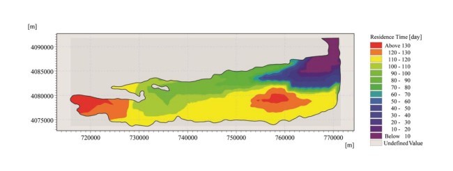
خلیج گرگان یک حوضچه نیمه بسته است که در جنوب شرقی دریای خزر واقعشده است. این خلیج بهعنوان محل سکونت پرندگان مهاجر شناختهشده است. همچنین بهعنوان یک مکان برای ماهیهای بومی شناختهشده است. بااینحال، ظاهراً، تحقیقات دقیق در مورد فرایندهای فیزیکی آن قبلاً انجامنشده است. در این مطالعه، مدل سهبعدی زوج هیدرودینامیک و مدل انتقال محلول برای بررسی جریان کلی، ساختار ترموهالین و زمان اقامت در خلیج گرگان مورداستفاده قرار گرفت. خروجیهای مدل بر اساس مجموعهای از مشاهدات میدانی تائید شد. ضریب اصطکاک پایین و ضریب انقباض شدت نور، بهمنظور دستیابی به توافق مطلوب با مشاهدات، تنظیم شد. نتایج نشان داد که با توجه به تعامل بین باتیمتری و بادهای غالب، جریان دوطرفه غالب در جریان کلی، در طول فصلهای مختلف، وجود داشته است. علاوه بر این، نوسانات دمای مطلوب در خلیج، با توجه به تنوع فصلی جریانهای جوی، فصلی بود. نتایج همچنین نشان داد که در طول بادهای غالب، مدتزمان اقامت در محدوده دامنه در خلیج گرگان حدود 95 روز هست. رودخانههایی که وارد خلیج گرگان میشوند بهعنوان منابع اصلی مواد مغذی در خلیج شناخته میشوند. ازآنجاییکه دهانه آنها در منطقهای در زمان اقامت 100 روز قرار دارد، خلیج گرگان میتواند در معرض خطر ائتروفیكی باشد؛ لازم است اقدامات پیشگیرانه در برابر تخریب کیفیت آب انجام شود.
1. مقدمه
خلیج گرگان (N,53.42-54.5 E 36.77-36.92) یک حوزه کمعمق است که در بخش جنوب شرقی دریای خزر در ایران با طول حدود 60 کیلومتر، حداکثر عرض 12 کیلومتر، عمق متوسط 1.8 متر و حداکثر عمق 5 متر در قسمت مرکزی خلیج قرارگرفته است(شکل 1).
پوشش منطقهای حدود 667 کیلومترمربع هست و خلیج گرگان دارای حجم تقریبی 1.2 کیلومترمکعب است. این خلیج از طرف جنوب با کوههای البرز، از سمت شرق با صحرای ترکمنستان، از سمت غرب با استان مازندران و از طرف شمال، با دریای خزر و بخشی از شبهجزیره میانکاله- یک سیستم مانع که خلیج را از دریای خزر جدا میکند- هممرز است.
خلیج گرگان با دریاچه خزر از طریق یک ورودی (که بهاصطلاح ورودی اصلی نامیده میشود) با عرض حدود 3 کیلومتر در گوشه شمال شرقی خلیج ارتباط دارد. کانال خوزینی که 6 کیلومتری غرب از ورودی اصلی است، یکی دیگر از اتصالات بین خلیج و دریای خزر است. عرض کانال حدود 200 متر است (شکل 1). بنابراین، خلیج نسبتاً از دریا جداشده است و انرژی موج کمی دارد. نوسانات سطح آب ناشی از جزر و مد در دریای خزر بسیار ناچیز است و به همین دلیل در خلیج گرگان نیز به همین صورت است. بنابراين تأثيرات جزر و مدي در فرآيند فيزيکي میتواند در مقايسه با اثرات شدت باد و تراکم در خليج گرگان (کوسارف 2005؛ کيتزوا و يانگ 2012) ناديده گرفته شود.
با توجه به دادههای بهدستآمده از یک ایستگاه هواشناسی سینوپتیک که در ورودی خلیج قرار دارد، بادهای غالب در منطقه موردمطالعه غرب با میانگین سرعت 5 متر بر ثانیه است. بااینحال، نوسانات فصلی وجود دارد. باد در خلیج گرگان عمدتاً از غرب و شمال غرب از ماه ژانویه تا اکتبر، شمال شرقی و شرقی در ماه نوامبر و در ماه دسامبر در شرق و غرب قرار دارد.
مجموع آب شیرین ورودی به خلیج گرگان، از طریق تخلیه رودخانه و بارش بسیار کم است. تخلیه همه ده رودخانه به خلیج حدود 1.3 مترمکعب در ثانیه است و میزان بارش در کل منطقه موردمطالعه 30.7 سانتیمتر / سال است. بااینوجود، تبخیر به میزان قابلتوجهی قویتر است: حدود 124.1 سانتیمتر / سال. بنابراین، خلیج حوضه تبخیر است و مانند یک حوضه معکوس رفتار میکند؛ ازاینرو، آب شور در آب خلیج تشکیل میشود. دریای خزر از طریق ورودیها، آب را برای کمبود آب فراهم میکند و به همین ترتیب، میانگین جریان سالانه ناشی از این میزان جریان آب حدود 26 مترمکعب بر ثانیه است.
رودخانههای ورودی به خلیج، ازجمله قرهسو (R1)، کردکی (R2)، کرکنده (R3)، باقو (R4)، گاز (R5)، نوکده (R6)، گلوگاه(R7)، رستم کلا (R8) بهشهر (R9) و زق مرز (R10) از زمینهای کشاورزی و مناطق شهری عبور میکنند و مواد مغذی گیاهی آبی و آلایندهها را به خلیج منتقل میکنند. رودخانه قرهسو واقع در گوشه جنوب شرقی خلیج (شکل 1)، مهمترین رودخانهها است، که بزرگترین جریان آب، با جریان 800 لیتر در ثانیه دارد. دو شهر بندر ترکمن و بندر گاس با جمعیت حدود 50،000 و 46،000 نفر در کنار خلیج قرار دارند. آبهای آلوده از گیاهان تصفیه فاضلاب این شهرها، که بعدها W1 و W2 نامیده میشوند، به خلیج ریخته میشوند که منبع دیگری از مواد مغذی محسوب میشوند (شکل 1).
کیفیت آب و ائتروفیكی در آبهای ساحلی نیمه محصورشده به فرایند شیمیایی، فیزیکی و بیولوژیکی وابسته است كه عمدتاً تحت تأثیر میزان تبادل آب بین آب دریا و دریای مجاور آن قرار دارند (یوان و همكاران 2007؛ Arega et al 2008). زمان اقامت مفهومی نسبت به مبادله آب است. زمان اقامت میتواند بهعنوان زمان صرف شده که حجمی آب از طریق ورودی حوضچه را ترک میکنند باشد (لف و پوهلان 1996؛ وان و همکاران 2013).
این مطالعه با استفاده از مدلسازی عددی به سه هدف اصلی پرداخته است: (1) نمایش وزش باد در خلیج (2) نشان دادن جریان کلی و ساختار ترموهالین در منطقه موردمطالعه و (3) محاسبه زمان اقامت در خلیج گرگان. به نظر میرسد این مطالعه اولین چیز برای بررسی کلی جریان عمومی در خلیج گرگان، ساختار ترموهالین و زمان اقامت در خلیج هست.
Abstract
Gorgan Bay is a semi-enclosed basin located in the southeast of the Caspian Sea, Iran. The bay is recognized as a resting place for migratory birds as well as a spawning habitat for native fish. However, apparently, no detailed research on its physical processes has previously been conducted. In this study, a 3D coupled hydrodynamic and solute transport model was used to investigate general circulation, thermohaline structure, and residence time in Gorgan Bay. Model outputs were validated against a set of field observations. Bottom friction and attenuation coefficient of light intensity were tuned in order to achieve optimum agreement with the observations. Results revealed that, due to the interaction between bathymetry and prevailing winds, a barotropic double-gyre circulation, dominating the general circulation, existed during all seasons in Gorgan Bay. Furthermore, temperature and salinity fluctuations in the bay were seasonal, due to the seasonal variability of atmospheric fluxes. Results also indicated that under the prevailing winds, the domain-averaged residence time in Gorgan Bay would be approximately 95 days. The rivers discharging into Gorgan Bay are considered as the main sources of nutrients in the bay. Since their mouths are located in the area with a residence time of over 100 days, Gorgan Bay could be at risk of eutrophication; it is necessary to adopt preventive measures against water quality degradation.
1 Introduction
Gorgan Bay (36.77–36.92° N and 53.42–54.05° E) is a relatively shallow, semi-enclosed basin located at the southeastern section of the Caspian Sea in Iran, with a length of about 60 km, a maximum width of 12 km, an average depth of 1.8 m, and a maximum depth of 5 m in central portion of the bay (Fig. 1).
Covering an area of about 667 km2 , Gorgan Bay has an approximate volume of 1.2 km3 . The bay is bounded to the south by Alborz Mountain Range, to the east by Turkmen Sahra, to the west by Mazandaran Province, and to the north partially by the Caspian Sea and partially by Miankaleh Peninsula—an elongated barrier system which separates the bay from the Caspian Sea.
Gorgan Bay is connected with the Caspian Sea through an inlet (hereafter called primary inlet) with a width of about 3 km in the north-eastern corner of the bay. Khozini Channel, which is 6 km to the west of the primary inlet, is another connection between the bay and the Caspian Sea. The channel’s width is about 200 m (Fig. 1). Therefore, the bay is relatively isolated from the sea and is characterized by significantly low wave energy (Bastami et al. 2012). The water level fluctuation due to tide is very negligible in the Caspian Sea and consequently in Gorgan Bay. Therefore, tidal impacts on physical processes can be ignored in comparison with the effects of wind and density gradients in Gorgan Bay (Kosarev 2005; Kitazawa and Yang 2012).
Considering data obtained from a synoptic weather station located next to the primary inlet of the bay, the annual prevailing wind in the study area is westerly with a mean speed of 5 m/s; however, it has seasonal fluctuations. Winds over Gorgan Bay are dominantly westerly and northwesterly from January to October, northeasterly and easterly in November, and again westerly and easterly in December.
The sum of all the fresh water entering Gorgan Bay, through river discharge and precipitation, is very low; discharge of all the ten rivers into the bay is about 1.3 m3 /s, and precipitation rate is 30.7 cm/year for the whole area under study. Nevertheless, evaporation is significantly stronger: it amounts to 124.1 cm/year. Therefore, the bay is an evaporation basin and behaves like an inverse estuary; hence, saltier, denser water is formed in the bay. The Caspian Sea provides water for deficiency through the inlets and, accordingly, the mean annual flow due to this water level tilting is about 26 m3 /s.
The rivers discharging into the bay, including Qareh Sou (R1), Kurdkuy (R2), Kar kandeh (R3), Baghu (R4), Gaz (R5), Now Kandeh (R6), Galugah (R7), Rostamkola (R8), Behshahr (R9), and Zagh Marz (R10), pass through agricultural lands and urban areas and transport aquatic plant nutrients and several pollutants into the bay (Bastami et al. 2012). Qareh Sou River, located in the southeast corner of the bay (Fig. 1), is the most important one, having the greatest water flow, with a flow of 800 L/s (Kurdi et al. 2015). Two cities, Bandar Torkaman and Bandar Gaz with populations of around 50,000 and 46,000 respectively, are located next to the bay. Polluted water from sewage treatment plants of these cities, hereafter called W1 and W2, pour into the bay, which is considered as another source of nutrients (Fig. 1).
Water quality and eutrophication in semi-enclosed coastal water bodies depend on their physical, chemical, and biological processes, which are mainly controlled by the rate of water exchange between the water body and its adjacent open sea (Yuan et al. 2007; Arega et al. 2008). Residence time is a concept relative to water exchange. Residence time can be defined as the time spent by a volume of water to leave a water body through its inlet (Luff and Pohlmann 1996; Wan et al. 2013).
This study used numerical modeling to address three main goals: (1) to depict wind-induced circulations in the bay, (2) to illustrate the general circulation and thermohaline structure in the study area, and (3) to calculate the residence time in Gorgan Bay. This study seems to be the first to investigate the detailed general circulation of Gorgan Bay, its thermohaline structure, and the residence time in the bay.
چکیده
1 مقدمه
2 مواد و روشها
2.1 مدل عددی
2.2 تنظیم شبیهسازیها
2.3 مشاهده منظم جریانهای سطح
3 نتایج و بحث
3.1 تجزیهوتحلیل حساسیت و کالیبراسیون
3.2 گردش ناشی از باد در خلیج گرگان
3.3 گردش عمومی و ساختار ترمو هالین در خلیج گرگان
3.3.1 گردش عمومی در خلیج
3.3.2 ساختارهای حرارتی در خلیج
3.4 زمان اقامت در خلیج گرگان
4 نتیجهگیری
منابع
Abstract
1 Introduction
2 Material and methods
2.1 The numerical model
2.2 Simulations setup
2.3 Field observation of surface currents
3 Results and discussion
3.1 Sensitivity analysis and calibration
3.2 Wind-induced circulation in Gorgan Bay
3.3 General circulation and thermohaline structure in Gorgan Bay
3.3.1 General circulation in the bay
3.3.2 Thermohaline structures in the bay
3.4 Residence time in Gorgan Bay
4 Conclusions
References